Fufore geodata
Fufore (Adamawa) is a seat of a second-order administrative division; located in Nigeria in Africa/Lagos (GMT+1) time zone. In our database, there are 451 cities with bigger population. Compared to other cities in Nigeria, 57% of cities are located further ↓South; 96.4% of cities are located further ←West and 65.4% of cities have higher elevation than Fufore. Note1


Fufore GPS coordinates[2]
9° 13' 18.3" North, 12° 38' 59.1" East
| Map corner | latitude | longitude |
|---|---|---|
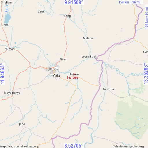
| Upper-left | 9.91509°, | 11.94663° |
| Center: | 9.22175°, | 12.64975° |
| Lower-right: | 8.52705°, | 13.35288° |
| Map W x H: | 154.3×154.3 km | = 95.9×95.9mi |
| max Lat: | 13.7543° ⇑43% North |
| Fufore: | 9.22175° |
| min Lat: | ⇓57% South 4.31231° |
| min Long | Fufore | max Long |
| 2.73333° | 12.64975° | 14.46552° |
| W 96.4%⇐ | ⇒3.6% E |
Elevation
Elevation of Fufore is 174 m = 571 ft, and this is 122.5 m = 402 ft below average elevation for this country.
| Max E: |
1599 m = 5246 ft | 65.4% |
| Avg. | 296.5 m = 973 ft | |
| Fufore | 174 m = 571 ft | |
Min E: |
2 m = 7 ft | 34.6% |
See also: Nigeria elevation on elevation.city.
Geographical zone
Fufore is located in North Torrid zone (between Equator and Tropic of Cancer). Distance of Equator is 1025.4 km =637.2 mi to South.| Distance of | km | miles | from Fufore |
|---|---|---|---|
| North Pole | 8981.7 | 5581 | to North |
| Arctic Circle | 6375.8 | 3961.7 | to North |
| Tropic Cancer | 1580.6 | 982.1 | to North |
| Equator | 1025.4 | 637.2 | to South |


Nearby cities:
15 places around Fufore: (largest is in red/bold)
• Demsa
60.4 km =37.5 mi,  295°
295°
• Girei
19.6 km =12.2 mi,  324°
324°
• Gombi
105.6 km =65.6 mi,  5°
5°
• Holma
87.4 km =54.3 mi,  30°
30°
• Jada
75 km =46.6 mi,  226°
226°
• Jimeta
22 km =13.7 mi,  286°
286°
• Lamurde
103.3 km =64.2 mi, 294°
• Maiha
106.2 km =66 mi,  35°
35°
• Mayo-Belwa
67.6 km =42 mi,  254°
254°
• Ngurore
45.6 km =28.3 mi,  279°
279°
• Numan
73.1 km =45.4 mi, 291°
• Shelleng
103 km =64 mi, 316°
• Song
67.3 km =41.8 mi,  357°
357°
• Yola
18.5 km =11.5 mi,  265°
265°
• Zing
102.3 km =63.6 mi,  255°
255°
Sources, notices
• [Note1] Compared only with cities in Nigeria existing in our database
• [Src1] Map data: © OpenStreetMap contributors (CC-BY-SA)
• [Src2] Other city data from geonames.org with taken over terms of usage.
• [Src3] Geographical zone / Annual Mean Temperature by Robert A. Rohde @ Wikipedia
