Mayo-Belwa geodata
Mayo-Belwa (Adamawa) is a seat of a second-order administrative division; located in Nigeria in Africa/Lagos (GMT+1) time zone. With population of 6,304 people, there are 433 cities with bigger population in this country. Compared to other cities in Nigeria, 55.4% of cities are located further ↓South; 94.3% of cities are located further ←West and 52.6% of cities have higher elevation than Mayo-Belwa. Note1


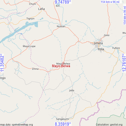
Mayo-Belwa GPS coordinates[2]
9° 3' 15.156" North, 12° 3' 28.584" East
| Map corner | latitude | longitude |
|---|---|---|
| Upper-left | 9.74789°, | 11.35482° |
| Center: | 9.05421°, | 12.05794° |
| Lower-right: | 8.35919°, | 12.76107° |
| Map W x H: | 154.4×154.4 km | = 95.9×95.9mi |
| max Lat: | 13.7543° ⇑44.6% North |
| Mayo-Belwa: | 9.05421° |
| min Lat: | ⇓55.4% South 4.31231° |
| min Long | Mayo-Belwa | max Long |
| 2.73333° | 12.05794° | 14.46552° |
| W 94.3%⇐ | ⇒5.7% E |
Elevation
Elevation of Mayo-Belwa is 269 m = 883 ft, and this is 27.5 m = 90 ft below average elevation for this country.
| Max E: |
1599 m = 5246 ft | 52.6% |
| Avg. | 296.5 m = 973 ft | |
| Mayo-Belwa | 269 m = 883 ft | |
Min E: |
2 m = 7 ft | 47.4% |
See also: Nigeria elevation on elevation.city.
Geographical zone
Mayo-Belwa is located in North Torrid zone (between Equator and Tropic of Cancer). Distance of Equator is 1006.7 km =625.5 mi to South.| Distance of | km | miles | from Mayo-Belwa |
|---|---|---|---|
| North Pole | 9000.3 | 5592.5 | to North |
| Arctic Circle | 6394.4 | 3973.3 | to North |
| Tropic Cancer | 1599.2 | 993.7 | to North |
| Equator | 1006.7 | 625.5 | to South |


Nearby cities:
15 places around Mayo-Belwa: (largest is in red/bold)
• Dadiya
92.8 km =57.7 mi,  312°
312°
• Demsa
45.8 km =28.5 mi,  13°
13°
• Fufore
67.6 km =42 mi,  74°
74°
• Ganye
68.9 km =42.8 mi,  180°
180°
• Girei
63.8 km =39.6 mi,  57°
57°
• Jada
34.8 km =21.6 mi,  162°
162°
• Jalingo
78.7 km =48.9 mi,  256°
256°
• Jimeta
50.6 km =31.4 mi, 60°
• Lamurde
68.1 km =42.3 mi,  334°
334°
• Lau
87.6 km =54.4 mi,  281°
281°
• Ngurore
32.9 km =20.4 mi,  37°
37°
• Numan
45.6 km =28.3 mi,  356°
356°
• Pantisawa
61.2 km =38 mi, 258°
• Yola
49.6 km =30.8 mi, 69°
• Zing
34.8 km =21.6 mi, 258°
Sources, notices
• [Note1] Compared only with cities in Nigeria existing in our database
• [Src1] Map data: © OpenStreetMap contributors (CC-BY-SA)
• [Src2] Other city data from geonames.org with taken over terms of usage.
• [Src3] Geographical zone / Annual Mean Temperature by Robert A. Rohde @ Wikipedia
