Pantisawa geodata
Pantisawa (Taraba) is a seat of a second-order administrative division; located in Nigeria in Africa/Lagos (GMT+1) time zone. In our database, there are 451 cities with bigger population. Compared to other cities in Nigeria, 54.7% of cities are located further ↓South; 92.3% of cities are located further ←West and 86% of cities have lower elevation than Pantisawa. Note1


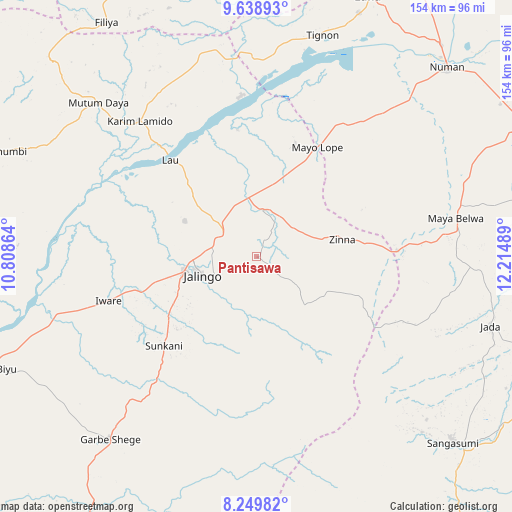
Pantisawa GPS coordinates[2]
8° 56' 42.144" North, 11° 30' 42.336" East
| Map corner | latitude | longitude |
|---|---|---|
| Upper-left | 9.63893°, | 10.80864° |
| Center: | 8.94504°, | 11.51176° |
| Lower-right: | 8.24982°, | 12.21489° |
| Map W x H: | 154.5×154.5 km | = 96×96mi |
| max Lat: | 13.7543° ⇑45.3% North |
| Pantisawa: | 8.94504° |
| min Lat: | ⇓54.7% South 4.31231° |
| min Long | Pantisawa | max Long |
| 2.73333° | 11.51176° | 14.46552° |
| W 92.3%⇐ | ⇒7.7% E |
Elevation
Elevation of Pantisawa is 511 m = 1677 ft, and this is 214.5 m = 704 ft above average elevation for this country.
| Max E: |
1599 m = 5246 ft | 14% |
| Pantisawa | 511 m 1677 ft | |
| Avg. | 296.5 m = 973 ft | |
Min E: |
2 m = 7 ft | 86% |
See also: Nigeria elevation on elevation.city.
Geographical zone
Pantisawa is located in North Torrid zone (between Equator and Tropic of Cancer). Distance of Equator is 994.6 km =618 mi to South.| Distance of | km | miles | from Pantisawa |
|---|---|---|---|
| North Pole | 9012.5 | 5600.1 | to North |
| Arctic Circle | 6406.6 | 3980.9 | to North |
| Tropic Cancer | 1611.3 | 1001.2 | to North |
| Equator | 994.6 | 618 | to South |


Nearby cities:
15 places around Pantisawa: (largest is in red/bold)
• Boh
96.5 km =60 mi,  344°
344°
• Dadiya
75.2 km =46.7 mi,  353°
353°
• Demsa
90.4 km =56.2 mi,  51°
51°
• Ganye
82 km =51 mi,  133°
133°
• Jada
73.7 km =45.8 mi,  106°
106°
• Jalingo
17.7 km =11 mi,  251°
251°
• Karim Lamido
54.4 km =33.8 mi,  319°
319°
• Lamurde
79.9 km =49.6 mi,  22°
22°
• Lau
39.1 km =24.3 mi, 318°
• Mayo-Belwa
61.2 km =38 mi,  78°
78°
• Mutum Biyu
87.9 km =54.6 mi, 247°
• Ngurore
88.6 km =55.1 mi,  64°
64°
• Numan
81.1 km =50.4 mi,  44°
44°
• Sunkani
38.8 km =24.1 mi,  226°
226°
• Zing
26.4 km =16.4 mi, 78°
Sources, notices
• [Note1] Compared only with cities in Nigeria existing in our database
• [Src1] Map data: © OpenStreetMap contributors (CC-BY-SA)
• [Src2] Other city data from geonames.org with taken over terms of usage.
• [Src3] Geographical zone / Annual Mean Temperature by Robert A. Rohde @ Wikipedia
