Jalingo geodata
Jalingo (Taraba) is a seat of a first-order administrative division; located in Nigeria in Africa/Lagos (GMT+1) time zone. With population of 117,757 people, there are 72 cities with bigger population in this country. Compared to other cities in Nigeria, 53.9% of cities are located further ↓South; 91.3% of cities are located further ←West and 59.9% of cities have higher elevation than Jalingo. Note1


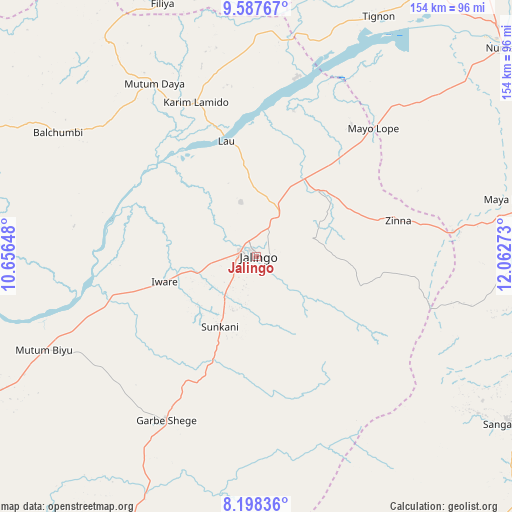
Jalingo GPS coordinates[2]
8° 53' 37.212" North, 11° 21' 34.56" East
| Map corner | latitude | longitude |
|---|---|---|
| Upper-left | 9.58767°, | 10.65648° |
| Center: | 8.89367°, | 11.3596° |
| Lower-right: | 8.19836°, | 12.06273° |
| Map W x H: | 154.5×154.5 km | = 96×96mi |
| max Lat: | 13.7543° ⇑46.1% North |
| Jalingo: | 8.89367° |
| min Lat: | ⇓53.9% South 4.31231° |
| min Long | Jalingo | max Long |
| 2.73333° | 11.3596° | 14.46552° |
| W 91.3%⇐ | ⇒8.7% E |
Elevation
Elevation of Jalingo is 208 m = 682 ft, and this is 88.5 m = 290 ft below average elevation for this country.
| Max E: |
1599 m = 5246 ft | 59.9% |
| Avg. | 296.5 m = 973 ft | |
| Jalingo | 208 m = 682 ft | |
Min E: |
2 m = 7 ft | 40.1% |
See also: Jalingo elevation on elevation.city.
Geographical zone
Jalingo is located in North Torrid zone (between Equator and Tropic of Cancer). Distance of Equator is 988.9 km =614.5 mi to South.| Distance of | km | miles | from Jalingo |
|---|---|---|---|
| North Pole | 9018.2 | 5603.6 | to North |
| Arctic Circle | 6412.3 | 3984.4 | to North |
| Tropic Cancer | 1617 | 1004.8 | to North |
| Equator | 988.9 | 614.5 | to South |


Nearby cities:
15 places around Jalingo: (largest is in red/bold)
• Boh
99.2 km =61.6 mi,  354°
354°
• Dadiya
80.8 km =50.2 mi,  5°
5°
• Ganye
91.5 km =56.9 mi,  123°
123°
• Jada
88.7 km =55.1 mi,  99°
99°
• Kaltungo
103.1 km =64.1 mi,  356°
356°
• Karim Lamido
50.4 km =31.3 mi,  337°
337°
• Lamurde
92.6 km =57.5 mi,  30°
30°
• Lau
36.2 km =22.5 mi, 345°
• Mayo-Belwa
78.7 km =48.9 mi,  76°
76°
• Mutum Biyu
70.2 km =43.6 mi,  246°
246°
• Ngurore
106.2 km =66 mi,  65°
65°
• Numan
97.2 km =60.4 mi,  49°
49°
• Pantisawa
17.7 km =11 mi, 71°
• Sunkani
24 km =14.9 mi,  207°
207°
• Zing
44 km =27.3 mi, 75°
Sources, notices
• [Note1] Compared only with cities in Nigeria existing in our database
• [Src1] Map data: © OpenStreetMap contributors (CC-BY-SA)
• [Src2] Other city data from geonames.org with taken over terms of usage.
• [Src3] Geographical zone / Annual Mean Temperature by Robert A. Rohde @ Wikipedia
