Lau geodata
Lau (Taraba) is a seat of a second-order administrative division; located in Nigeria in Africa/Lagos (GMT+1) time zone. With population of 12,657 people, there are 282 cities with bigger population in this country. Compared to other cities in Nigeria, 56.7% of cities are located further ↓South; 90.5% of cities are located further ←West and 73% of cities have higher elevation than Lau. Note1


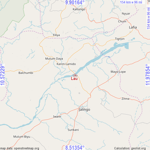
Lau GPS coordinates[2]
9° 12' 29.772" North, 11° 16' 31.476" East
| Map corner | latitude | longitude |
|---|---|---|
| Upper-left | 9.90164°, | 10.57229° |
| Center: | 9.20827°, | 11.27541° |
| Lower-right: | 8.51354°, | 11.97854° |
| Map W x H: | 154.3×154.3 km | = 95.9×95.9mi |
| max Lat: | 13.7543° ⇑43.3% North |
| Lau: | 9.20827° |
| min Lat: | ⇓56.7% South 4.31231° |
| min Long | Lau | max Long |
| 2.73333° | 11.27541° | 14.46552° |
| W 90.5%⇐ | ⇒9.5% E |
Elevation
Elevation of Lau is 132 m = 433 ft, and this is 164.5 m = 540 ft below average elevation for this country.
| Max E: |
1599 m = 5246 ft | 73% |
| Avg. | 296.5 m = 973 ft | |
| Lau | 132 m = 433 ft | |
Min E: |
2 m = 7 ft | 27% |
See also: Nigeria elevation on elevation.city.
Geographical zone
Lau is located in North Torrid zone (between Equator and Tropic of Cancer). Distance of Equator is 1023.9 km =636.2 mi to South.| Distance of | km | miles | from Lau |
|---|---|---|---|
| North Pole | 8983.2 | 5581.9 | to North |
| Arctic Circle | 6377.3 | 3962.7 | to North |
| Tropic Cancer | 1582.1 | 983.1 | to North |
| Equator | 1023.9 | 636.2 | to South |


Nearby cities:
15 places around Lau: (largest is in red/bold)
• Billiri
73.3 km =45.5 mi,  355°
355°
• Billiri
76.1 km =47.3 mi, 355°
• Boh
63.8 km =39.6 mi,  0°
0°
• Dadiya
48.6 km =30.2 mi,  20°
20°
• Jalingo
36.2 km =22.5 mi,  165°
165°
• Kaltungo
68.1 km =42.3 mi, 3°
• Karim Lamido
15.2 km =9.4 mi,  320°
320°
• Lamurde
72.1 km =44.8 mi,  51°
51°
• Mayo-Belwa
87.6 km =54.4 mi,  101°
101°
• Mutum Biyu
83.7 km =52 mi,  221°
221°
• Numan
87.6 km =54.4 mi,  71°
71°
• Pantisawa
39.1 km =24.3 mi,  138°
138°
• Pindiga
93.3 km =58 mi,  337°
337°
• Sunkani
56.2 km =34.9 mi,  181°
181°
• Zing
57.2 km =35.5 mi,  115°
115°
Sources, notices
• [Note1] Compared only with cities in Nigeria existing in our database
• [Src1] Map data: © OpenStreetMap contributors (CC-BY-SA)
• [Src2] Other city data from geonames.org with taken over terms of usage.
• [Src3] Geographical zone / Annual Mean Temperature by Robert A. Rohde @ Wikipedia
