Besse geodata
Besse (Kebbi) is a seat of a second-order administrative division; located in Nigeria in Africa/Lagos (GMT+1) time zone. In our database, there are 451 cities with bigger population. Compared to other cities in Nigeria, 74.6% of cities are located further ↓South; 88.2% of cities are located further →East and 67.2% of cities have higher elevation than Besse. Note1


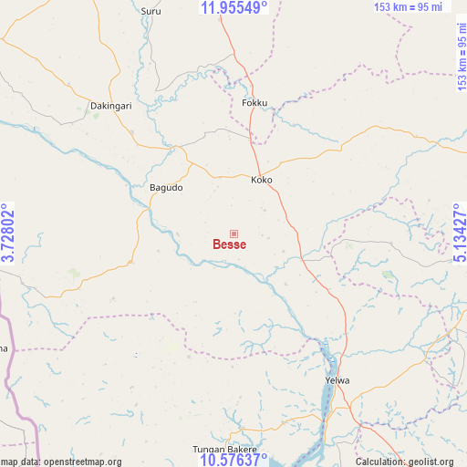
Besse GPS coordinates[2]
11° 16' 0.336" North, 4° 25' 52.104" East
| Map corner | latitude | longitude |
|---|---|---|
| Upper-left | 11.95549°, | 3.72802° |
| Center: | 11.26676°, | 4.43114° |
| Lower-right: | 10.57637°, | 5.13427° |
| Map W x H: | 153.3×153.3 km | = 95.3×95.3mi |
| max Lat: | 13.7543° ⇑25.4% North |
| Besse: | 11.26676° |
| min Lat: | ⇓74.6% South 4.31231° |
| min Long | Besse | max Long |
| 2.73333° | 4.43114° | 14.46552° |
| W 11.8%⇐ | ⇒88.2% E |
Elevation
Elevation of Besse is 161 m = 528 ft, and this is 135.5 m = 445 ft below average elevation for this country.
| Max E: |
1599 m = 5246 ft | 67.2% |
| Avg. | 296.5 m = 973 ft | |
| Besse | 161 m = 528 ft | |
Min E: |
2 m = 7 ft | 32.8% |
See also: Nigeria elevation on elevation.city.
Geographical zone
Besse is located in North Torrid zone (between Equator and Tropic of Cancer). Distance of Equator is 1252.7 km =778.4 mi to South.| Distance of | km | miles | from Besse |
|---|---|---|---|
| North Pole | 8754.3 | 5439.7 | to North |
| Arctic Circle | 6148.4 | 3820.4 | to North |
| Tropic Cancer | 1353.2 | 840.8 | to North |
| Equator | 1252.7 | 778.4 | to South |


Nearby cities:
15 places around Besse: (largest is in red/bold)
• Agwara
64.5 km =40.1 mi,  165°
165°
• Bagudo
27.1 km =16.8 mi,  304°
304°
• Bin Yauri
68 km =42.3 mi,  142°
142°
• Dabai
87.7 km =54.5 mi,  74°
74°
• Dakingari
58.5 km =36.4 mi,  316°
316°
• Duku
52 km =32.3 mi,  93°
93°
• Kende
33.7 km =20.9 mi,  326°
326°
• Konkwesso
59.1 km =36.7 mi,  217°
217°
• Mahuta
67.9 km =42.2 mi,  62°
62°
• Maiyama
90.9 km =56.5 mi,  355°
355°
• Nasko
99.8 km =62 mi,  149°
149°
• Rijau
91.7 km =57 mi,  101°
101°
• Shanga
17.2 km =10.7 mi,  110°
110°
• Yelwa
58.8 km =36.5 mi, 144°
• Zuru
89.6 km =55.7 mi,  77°
77°
Sources, notices
• [Note1] Compared only with cities in Nigeria existing in our database
• [Src1] Map data: © OpenStreetMap contributors (CC-BY-SA)
• [Src2] Other city data from geonames.org with taken over terms of usage.
• [Src3] Geographical zone / Annual Mean Temperature by Robert A. Rohde @ Wikipedia
