Gashua geodata
Gashua (Yobe) is a seat of a second-order administrative division; located in Nigeria in Africa/Lagos (GMT+1) time zone. With population of 125,817 people, there are 68 cities with bigger population in this country. Compared to other cities in Nigeria, 95.7% of cities are located further ↓South; 89.1% of cities are located further ←West and 59.1% of cities have lower elevation than Gashua. Note1


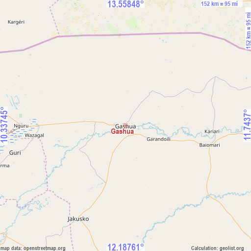
Gashua GPS coordinates[2]
12° 52' 26.328" North, 11° 2' 26.052" East
| Map corner | latitude | longitude |
|---|---|---|
| Upper-left | 13.55848°, | 10.33745° |
| Center: | 12.87398°, | 11.04057° |
| Lower-right: | 12.18761°, | 11.7437° |
| Map W x H: | 152.4×152.4 km | = 94.7×94.7mi |
| max Lat: | 13.7543° ⇑4.3% North |
| Gashua: | 12.87398° |
| min Lat: | ⇓95.7% South 4.31231° |
| min Long | Gashua | max Long |
| 2.73333° | 11.04057° | 14.46552° |
| W 89.1%⇐ | ⇒10.9% E |
Elevation
Elevation of Gashua is 339 m = 1112 ft, and this is 42.5 m = 139 ft above average elevation for this country.
| Max E: |
1599 m = 5246 ft | 40.9% |
| Gashua | 339 m 1112 ft | |
| Avg. | 296.5 m = 973 ft | |
Min E: |
2 m = 7 ft | 59.1% |
See also: Gashua elevation on elevation.city.
Geographical zone
Gashua is located in North Torrid zone (between Equator and Tropic of Cancer). Distance of this Northern Tropic circle is 1174.5 km =729.8 mi to North.| Distance of | km | miles | from Gashua |
|---|---|---|---|
| North Pole | 8575.6 | 5328.6 | to North |
| Arctic Circle | 5969.7 | 3709.4 | to North |
| Tropic Cancer | 1174.5 | 729.8 | to North |
| Equator | 1431.5 | 889.5 | to South |


Nearby cities:
15 places around Gashua: (largest is in red/bold)
• Birniwa
87.7 km =54.5 mi,  263°
263°
• Dapchi
65.2 km =40.5 mi,  130°
130°
• Gamawa
98.7 km =61.3 mi,  213°
213°
• Geidam
96.1 km =59.7 mi,  88°
88°
• Gorgoram
44.8 km =27.8 mi,  234°
234°
• Guri
69.2 km =43 mi, 256°
• Gwio Kura
22.3 km =13.9 mi,  172°
172°
• Jajimaji
25.5 km =15.8 mi,  276°
276°
• Jakusko
63 km =39.1 mi, 207°
• Katagum
99.5 km =61.8 mi, 228°
• Kiri Kasamma
87.6 km =54.4 mi, 256°
• Kumagunnam
53.9 km =33.5 mi,  305°
305°
• Lajere
108.4 km =67.4 mi,  156°
156°
• Machina
111.3 km =69.2 mi,  285°
285°
• Nguru
63.4 km =39.4 mi,  270°
270°
Sources, notices
• [Note1] Compared only with cities in Nigeria existing in our database
• [Src1] Map data: © OpenStreetMap contributors (CC-BY-SA)
• [Src2] Other city data from geonames.org with taken over terms of usage.
• [Src3] Geographical zone / Annual Mean Temperature by Robert A. Rohde @ Wikipedia
