Jakusko geodata
Jakusko (Yobe) is a seat of a second-order administrative division; located in Nigeria in Africa/Lagos (GMT+1) time zone. In our database, there are 451 cities with bigger population. Compared to other cities in Nigeria, 89% of cities are located further ↓South; 88.5% of cities are located further ←West and 61% of cities have lower elevation than Jakusko. Note1


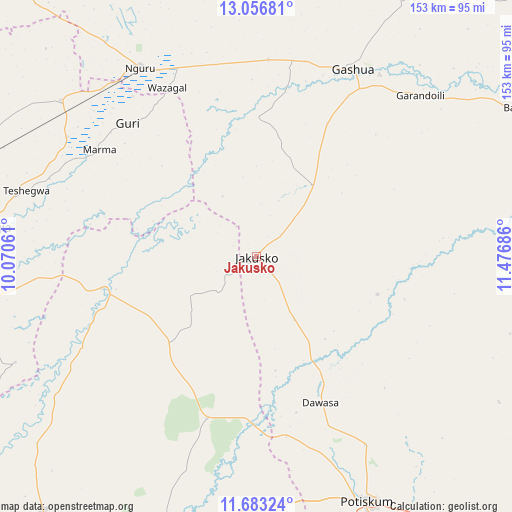
Jakusko GPS coordinates[2]
12° 22' 15.348" North, 10° 46' 25.428" East
| Map corner | latitude | longitude |
|---|---|---|
| Upper-left | 13.05681°, | 10.07061° |
| Center: | 12.37093°, | 10.77373° |
| Lower-right: | 11.68324°, | 11.47686° |
| Map W x H: | 152.7×152.7 km | = 94.9×94.9mi |
| max Lat: | 13.7543° ⇑11% North |
| Jakusko: | 12.37093° |
| min Lat: | ⇓89% South 4.31231° |
| min Long | Jakusko | max Long |
| 2.73333° | 10.77373° | 14.46552° |
| W 88.5%⇐ | ⇒11.5% E |
Elevation
Elevation of Jakusko is 352 m = 1155 ft, and this is 55.5 m = 182 ft above average elevation for this country.
| Max E: |
1599 m = 5246 ft | 39% |
| Jakusko | 352 m 1155 ft | |
| Avg. | 296.5 m = 973 ft | |
Min E: |
2 m = 7 ft | 61% |
See also: Nigeria elevation on elevation.city.
Geographical zone
Jakusko is located in North Torrid zone (between Equator and Tropic of Cancer). Distance of this Northern Tropic circle is 1230.4 km =764.5 mi to North.| Distance of | km | miles | from Jakusko |
|---|---|---|---|
| North Pole | 8631.5 | 5363.4 | to North |
| Arctic Circle | 6025.7 | 3744.2 | to North |
| Tropic Cancer | 1230.4 | 764.5 | to North |
| Equator | 1375.5 | 854.7 | to South |


Nearby cities:
15 places around Jakusko: (largest is in red/bold)
• Birniwa
74.7 km =46.4 mi,  308°
308°
• Dambam
77.3 km =48 mi,  185°
185°
• Dapchi
80 km =49.7 mi,  80°
80°
• Gamawa
36.8 km =22.9 mi,  224°
224°
• Gashua
63 km =39.1 mi,  27°
27°
• Gorgoram
30.8 km =19.1 mi,  345°
345°
• Guri
55.2 km =34.3 mi,  315°
315°
• Gwio Kura
46.4 km =28.8 mi,  43°
43°
• Hadejia
80.1 km =49.8 mi,  276°
276°
• Jajimaji
58.8 km =36.5 mi,  3°
3°
• Katagum
47 km =29.2 mi,  258°
258°
• Kiri Kasamma
66.8 km =41.5 mi,  302°
302°
• Madara
74.7 km =46.4 mi,  208°
208°
• Nguru
66 km =41 mi,  328°
328°
• Sabon Garin Nangere
66.5 km =41.3 mi,  150°
150°
Sources, notices
• [Note1] Compared only with cities in Nigeria existing in our database
• [Src1] Map data: © OpenStreetMap contributors (CC-BY-SA)
• [Src2] Other city data from geonames.org with taken over terms of usage.
• [Src3] Geographical zone / Annual Mean Temperature by Robert A. Rohde @ Wikipedia
