Bunza geodata
Bunza (Kebbi) is a seat of a second-order administrative division; located in Nigeria in Africa/Lagos (GMT+1) time zone. In our database, there are 451 cities with bigger population. Compared to other cities in Nigeria, 84.9% of cities are located further ↓South; 92% of cities are located further →East and 62.1% of cities have higher elevation than Bunza. Note1


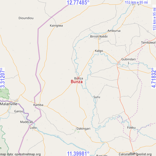
Bunza GPS coordinates[2]
12° 5' 17.556" North, 4° 0' 54.72" East
| Map corner | latitude | longitude |
|---|---|---|
| Upper-left | 12.77485°, | 3.31207° |
| Center: | 12.08821°, | 4.0152° |
| Lower-right: | 11.39981°, | 4.71832° |
| Map W x H: | 152.9×152.9 km | = 95×95mi |
| max Lat: | 13.7543° ⇑15.1% North |
| Bunza: | 12.08821° |
| min Lat: | ⇓84.9% South 4.31231° |
| min Long | Bunza | max Long |
| 2.73333° | 4.0152° | 14.46552° |
| W 8%⇐ | ⇒92% E |
Elevation
Elevation of Bunza is 193 m = 633 ft, and this is 103.5 m = 340 ft below average elevation for this country.
| Max E: |
1599 m = 5246 ft | 62.1% |
| Avg. | 296.5 m = 973 ft | |
| Bunza | 193 m = 633 ft | |
Min E: |
2 m = 7 ft | 37.9% |
See also: Nigeria elevation on elevation.city.
Geographical zone
Bunza is located in North Torrid zone (between Equator and Tropic of Cancer). Distance of this Northern Tropic circle is 1261.8 km =784 mi to North.| Distance of | km | miles | from Bunza |
|---|---|---|---|
| North Pole | 8663 | 5382.9 | to North |
| Arctic Circle | 6057.1 | 3763.7 | to North |
| Tropic Cancer | 1261.8 | 784 | to North |
| Equator | 1344.1 | 835.2 | to South |


Nearby cities:
15 places around Bunza: (largest is in red/bold)
• Aliero
54.3 km =33.7 mi,  65°
65°
• Argungu
91.6 km =56.9 mi,  37°
37°
• Bagudo
79.5 km =49.4 mi,  163°
163°
• Birnin Kebbi
45.2 km =28.1 mi,  25°
25°
• Dakingari
49.2 km =30.6 mi,  174°
174°
• Gulma
71.8 km =44.6 mi, 30°
• Gwandu
82.3 km =51.1 mi,  55°
55°
• Jega
42.4 km =26.3 mi, 69°
• Kalgo
33.3 km =20.7 mi, 37°
• Kamba
47.2 km =29.3 mi,  236°
236°
• Kangiwa
56 km =34.8 mi,  337°
337°
• Kebbe
78.3 km =48.7 mi,  86°
86°
• Kende
68.6 km =42.6 mi, 157°
• Maiyama
38.5 km =23.9 mi, 90°
• Tambuwal
77.1 km =47.9 mi, 62°
Sources, notices
• [Note1] Compared only with cities in Nigeria existing in our database
• [Src1] Map data: © OpenStreetMap contributors (CC-BY-SA)
• [Src2] Other city data from geonames.org with taken over terms of usage.
• [Src3] Geographical zone / Annual Mean Temperature by Robert A. Rohde @ Wikipedia
