Maigana geodata
Maigana (Kaduna) is a seat of a second-order administrative division; located in Nigeria in Africa/Lagos (GMT+1) time zone. In our database, there are 451 cities with bigger population. Compared to other cities in Nigeria, 72.7% of cities are located further ↓South; 62.5% of cities are located further ←West and 95% of cities have lower elevation than Maigana. Note1


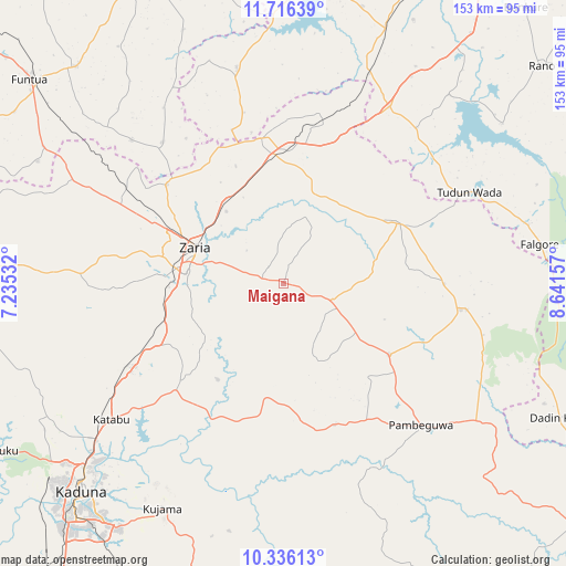
Maigana GPS coordinates[2]
11° 1' 37.452" North, 7° 56' 18.384" East
| Map corner | latitude | longitude |
|---|---|---|
| Upper-left | 11.71639°, | 7.23532° |
| Center: | 11.02707°, | 7.93844° |
| Lower-right: | 10.33613°, | 8.64157° |
| Map W x H: | 153.5×153.5 km | = 95.4×95.4mi |
| max Lat: | 13.7543° ⇑27.3% North |
| Maigana: | 11.02707° |
| min Lat: | ⇓72.7% South 4.31231° |
| min Long | Maigana | max Long |
| 2.73333° | 7.93844° | 14.46552° |
| W 62.5%⇐ | ⇒37.5% E |
Elevation
Elevation of Maigana is 658 m = 2159 ft, and this is 361.5 m = 1186 ft above average elevation for this country.
| Max E: |
1599 m = 5246 ft | 5% |
| Maigana | 658 m 2159 ft | |
| Avg. | 296.5 m = 973 ft | |
Min E: |
2 m = 7 ft | 95% |
See also: Nigeria elevation on elevation.city.
Geographical zone
Maigana is located in North Torrid zone (between Equator and Tropic of Cancer). Distance of Equator is 1226.1 km =761.9 mi to South.| Distance of | km | miles | from Maigana |
|---|---|---|---|
| North Pole | 8781 | 5456.3 | to North |
| Arctic Circle | 6175.1 | 3837 | to North |
| Tropic Cancer | 1379.8 | 857.4 | to North |
| Equator | 1226.1 | 761.9 | to South |


Nearby cities:
15 places around Maigana: (largest is in red/bold)
• Anchau
50.1 km =31.1 mi,  98°
98°
• Dan Gora
61.1 km =38 mi,  22°
22°
• Danja
56.7 km =35.2 mi,  313°
313°
• Dutsen Wai
34.6 km =21.5 mi,  124°
124°
• Giwa
62.2 km =38.6 mi,  301°
301°
• Hunkuyi
41.3 km =25.7 mi, 310°
• Igabi
34.7 km =21.6 mi,  224°
224°
• Ikara
35.3 km =21.9 mi,  62°
62°
• Kauru
55.3 km =34.4 mi,  155°
155°
• Kujama
71.3 km =44.3 mi,  207°
207°
• Makarfi
39.4 km =24.5 mi,  350°
350°
• Rogo
59.8 km =37.2 mi, 347°
• Soba
14 km =8.7 mi,  111°
111°
• Tudun Wada
56.2 km =34.9 mi, 63°
• Zaria
25.3 km =15.7 mi,  291°
291°
Sources, notices
• [Note1] Compared only with cities in Nigeria existing in our database
• [Src1] Map data: © OpenStreetMap contributors (CC-BY-SA)
• [Src2] Other city data from geonames.org with taken over terms of usage.
• [Src3] Geographical zone / Annual Mean Temperature by Robert A. Rohde @ Wikipedia
