Ganye geodata
Ganye (Adamawa) is a seat of a second-order administrative division; located in Nigeria in Africa/Lagos (GMT+1) time zone. With population of 15,178 people, there are 238 cities with bigger population in this country. Compared to other cities in Nigeria, 50.4% of cities are located further ↓South; 94.1% of cities are located further ←West and 81.8% of cities have lower elevation than Ganye. Note1


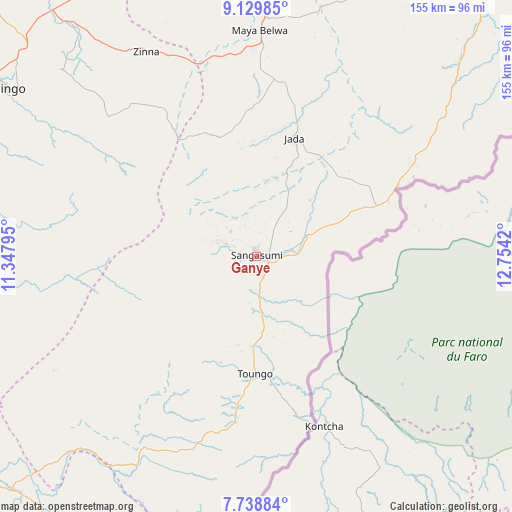
Ganye GPS coordinates[2]
8° 26' 5.892" North, 12° 3' 3.852" East
| Map corner | latitude | longitude |
|---|---|---|
| Upper-left | 9.12985°, | 11.34795° |
| Center: | 8.43497°, | 12.05107° |
| Lower-right: | 7.73884°, | 12.7542° |
| Map W x H: | 154.7×154.7 km | = 96.1×96.1mi |
| max Lat: | 13.7543° ⇑49.6% North |
| Ganye: | 8.43497° |
| min Lat: | ⇓50.4% South 4.31231° |
| min Long | Ganye | max Long |
| 2.73333° | 12.05107° | 14.46552° |
| W 94.1%⇐ | ⇒5.9% E |
Elevation
Elevation of Ganye is 484 m = 1588 ft, and this is 187.5 m = 615 ft above average elevation for this country.
| Max E: |
1599 m = 5246 ft | 18.2% |
| Ganye | 484 m 1588 ft | |
| Avg. | 296.5 m = 973 ft | |
Min E: |
2 m = 7 ft | 81.8% |
See also: Nigeria elevation on elevation.city.
Geographical zone
Ganye is located in North Torrid zone (between Equator and Tropic of Cancer). Distance of Equator is 937.9 km =582.8 mi to South.| Distance of | km | miles | from Ganye |
|---|---|---|---|
| North Pole | 9069.2 | 5635.3 | to North |
| Arctic Circle | 6463.3 | 4016.1 | to North |
| Tropic Cancer | 1668 | 1036.4 | to North |
| Equator | 937.9 | 582.8 | to South |


Nearby cities:
15 places around Ganye: (largest is in red/bold)
• Demsa
114 km =70.8 mi,  5°
5°
• Fufore
109.5 km =68 mi,  36°
36°
• Girei
116.9 km =72.6 mi,  27°
27°
• Jada
37.6 km =23.4 mi,  17°
17°
• Jalingo
91.5 km =56.9 mi,  303°
303°
• Jimeta
104 km =64.6 mi, 25°
• Lau
121.1 km =75.2 mi,  315°
315°
• Mayo-Belwa
68.9 km =42.8 mi,  0°
0°
• Ngurore
97.2 km =60.4 mi, 12°
• Numan
114.4 km =71.1 mi,  358°
358°
• Pantisawa
82 km =51 mi,  313°
313°
• Sunkani
92.2 km =57.3 mi,  288°
288°
• Toungo
35.3 km =21.9 mi,  180°
180°
• Yola
98.1 km =61 mi, 28°
• Zing
70.2 km =43.6 mi,  331°
331°
Sources, notices
• [Note1] Compared only with cities in Nigeria existing in our database
• [Src1] Map data: © OpenStreetMap contributors (CC-BY-SA)
• [Src2] Other city data from geonames.org with taken over terms of usage.
• [Src3] Geographical zone / Annual Mean Temperature by Robert A. Rohde @ Wikipedia
