Dutsen Wai geodata
Dutsen Wai (Kaduna) is a populated place; located in Nigeria in Africa/Lagos (GMT+1) time zone. With population of 22,062 people, there are 187 cities with bigger population in this country. Compared to other cities in Nigeria, 71.7% of cities are located further ↓South; 66.9% of cities are located further ←West and 96.6% of cities have lower elevation than Dutsen Wai. Note1


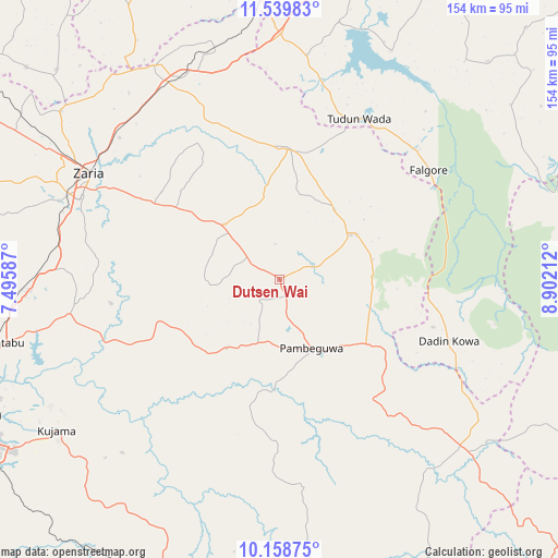
Dutsen Wai GPS coordinates[2]
10° 51' 0.324" North, 8° 11' 56.4" East
| Map corner | latitude | longitude |
|---|---|---|
| Upper-left | 11.53983°, | 7.49587° |
| Center: | 10.85009°, | 8.199° |
| Lower-right: | 10.15875°, | 8.90212° |
| Map W x H: | 153.6×153.6 km | = 95.4×95.4mi |
| max Lat: | 13.7543° ⇑28.3% North |
| Dutsen Wai: | 10.85009° |
| min Lat: | ⇓71.7% South 4.31231° |
| min Long | Dutsen Wai | max Long |
| 2.73333° | 8.199° | 14.46552° |
| W 66.9%⇐ | ⇒33.1% E |
Elevation
Elevation of Dutsen Wai is 694 m = 2277 ft, and this is 397.5 m = 1304 ft above average elevation for this country.
| Max E: |
1599 m = 5246 ft | 3.4% |
| Dutsen Wai | 694 m 2277 ft | |
| Avg. | 296.5 m = 973 ft | |
Min E: |
2 m = 7 ft | 96.6% |
See also: Nigeria elevation on elevation.city.
Geographical zone
Dutsen Wai is located in North Torrid zone (between Equator and Tropic of Cancer). Distance of Equator is 1206.4 km =749.6 mi to South.| Distance of | km | miles | from Dutsen Wai |
|---|---|---|---|
| North Pole | 8800.6 | 5468.4 | to North |
| Arctic Circle | 6194.8 | 3849.3 | to North |
| Tropic Cancer | 1399.5 | 869.6 | to North |
| Equator | 1206.4 | 749.6 | to South |


Nearby cities:
15 places around Dutsen Wai: (largest is in red/bold)
• Anchau
24.5 km =15.2 mi,  59°
59°
• Dan Gora
76.3 km =47.4 mi,  356°
356°
• Hunkuyi
75.8 km =47.1 mi,  307°
307°
• Igabi
53.1 km =33 mi,  264°
264°
• Ikara
36.2 km =22.5 mi,  4°
4°
• Kauru
30.9 km =19.2 mi,  189°
189°
• Kujama
75.2 km =46.7 mi,  234°
234°
• Lere
65.8 km =40.9 mi,  141°
141°
• Maigana
34.6 km =21.5 mi,  304°
304°
• Makarfi
68.1 km =42.3 mi,  329°
329°
• Ririwai
60.5 km =37.6 mi,  101°
101°
• Saminaka
72.2 km =44.9 mi,  132°
132°
• Soba
21.3 km =13.2 mi, 313°
• Tudun Wada
49.5 km =30.8 mi,  26°
26°
• Zaria
59.6 km =37 mi, 299°
Sources, notices
• [Note1] Compared only with cities in Nigeria existing in our database
• [Src1] Map data: © OpenStreetMap contributors (CC-BY-SA)
• [Src2] Other city data from geonames.org with taken over terms of usage.
• [Src3] Geographical zone / Annual Mean Temperature by Robert A. Rohde @ Wikipedia
