Soba geodata
Soba (Kaduna) is a populated place; located in Nigeria in Africa/Lagos (GMT+1) time zone. With population of 15,715 people, there are 232 cities with bigger population in this country. Compared to other cities in Nigeria, 72.4% of cities are located further ↓South; 64.8% of cities are located further ←West and 96.2% of cities have lower elevation than Soba. Note1


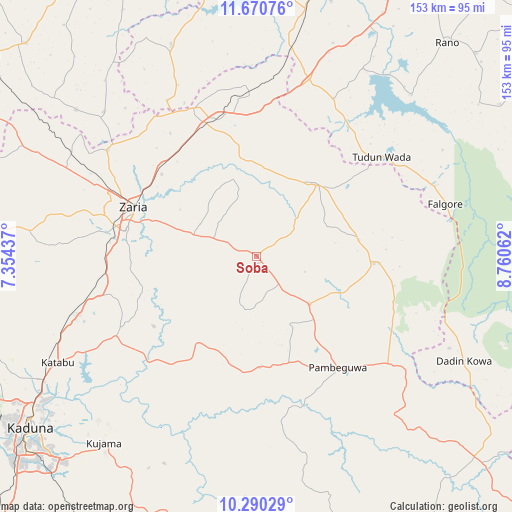
Soba GPS coordinates[2]
10° 58' 52.788" North, 8° 3' 26.964" East
| Map corner | latitude | longitude |
|---|---|---|
| Upper-left | 11.67076°, | 7.35437° |
| Center: | 10.98133°, | 8.05749° |
| Lower-right: | 10.29029°, | 8.76062° |
| Map W x H: | 153.5×153.5 km | = 95.4×95.4mi |
| max Lat: | 13.7543° ⇑27.6% North |
| Soba: | 10.98133° |
| min Lat: | ⇓72.4% South 4.31231° |
| min Long | Soba | max Long |
| 2.73333° | 8.05749° | 14.46552° |
| W 64.8%⇐ | ⇒35.2% E |
Elevation
Elevation of Soba is 683 m = 2241 ft, and this is 386.5 m = 1268 ft above average elevation for this country.
| Max E: |
1599 m = 5246 ft | 3.8% |
| Soba | 683 m 2241 ft | |
| Avg. | 296.5 m = 973 ft | |
Min E: |
2 m = 7 ft | 96.2% |
See also: Nigeria elevation on elevation.city.
Geographical zone
Soba is located in North Torrid zone (between Equator and Tropic of Cancer). Distance of Equator is 1221 km =758.7 mi to South.| Distance of | km | miles | from Soba |
|---|---|---|---|
| North Pole | 8786.1 | 5459.4 | to North |
| Arctic Circle | 6180.2 | 3840.2 | to North |
| Tropic Cancer | 1384.9 | 860.5 | to North |
| Equator | 1221 | 758.7 | to South |


Nearby cities:
15 places around Soba: (largest is in red/bold)
• Anchau
36.6 km =22.7 mi,  93°
93°
• Dan Gora
62.4 km =38.8 mi,  9°
9°
• Danja
69.8 km =43.4 mi,  309°
309°
• Dutsen Wai
21.3 km =13.2 mi,  133°
133°
• Giwa
76 km =47.2 mi,  299°
299°
• Hunkuyi
54.7 km =34 mi, 305°
• Igabi
42.2 km =26.2 mi,  242°
242°
• Ikara
28.2 km =17.5 mi,  40°
40°
• Kauru
46.2 km =28.7 mi,  167°
167°
• Kujama
74.1 km =46 mi,  218°
218°
• Maigana
14 km =8.7 mi,  291°
291°
• Makarfi
48.1 km =29.9 mi,  336°
336°
• Rogo
68.5 km =42.6 mi, 338°
• Tudun Wada
47.8 km =29.7 mi,  51°
51°
• Zaria
39.3 km =24.4 mi, 291°
Sources, notices
• [Note1] Compared only with cities in Nigeria existing in our database
• [Src1] Map data: © OpenStreetMap contributors (CC-BY-SA)
• [Src2] Other city data from geonames.org with taken over terms of usage.
• [Src3] Geographical zone / Annual Mean Temperature by Robert A. Rohde @ Wikipedia
