Kujama geodata
Kujama (Kaduna) is a seat of a second-order administrative division; located in Nigeria in Africa/Lagos (GMT+1) time zone. With population of 12,967 people, there are 273 cities with bigger population in this country. Compared to other cities in Nigeria, 68.5% of cities are located further ↓South; 56.4% of cities are located further ←West and 95.2% of cities have lower elevation than Kujama. Note1


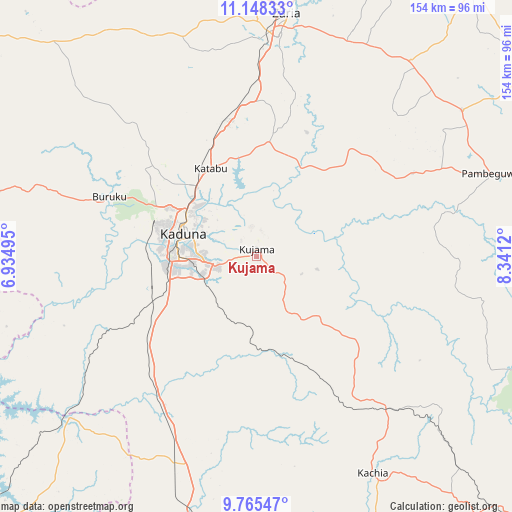
Kujama GPS coordinates[2]
10° 27' 27.612" North, 7° 38' 17.088" East
| Map corner | latitude | longitude |
|---|---|---|
| Upper-left | 11.14833°, | 6.93495° |
| Center: | 10.45767°, | 7.63808° |
| Lower-right: | 9.76547°, | 8.3412° |
| Map W x H: | 153.8×153.8 km | = 95.6×95.6mi |
| max Lat: | 13.7543° ⇑31.5% North |
| Kujama: | 10.45767° |
| min Lat: | ⇓68.5% South 4.31231° |
| min Long | Kujama | max Long |
| 2.73333° | 7.63808° | 14.46552° |
| W 56.4%⇐ | ⇒43.6% E |
Elevation
Elevation of Kujama is 663 m = 2175 ft, and this is 366.5 m = 1202 ft above average elevation for this country.
| Max E: |
1599 m = 5246 ft | 4.8% |
| Kujama | 663 m 2175 ft | |
| Avg. | 296.5 m = 973 ft | |
Min E: |
2 m = 7 ft | 95.2% |
See also: Nigeria elevation on elevation.city.
Geographical zone
Kujama is located in North Torrid zone (between Equator and Tropic of Cancer). Distance of Equator is 1162.8 km =722.5 mi to South.| Distance of | km | miles | from Kujama |
|---|---|---|---|
| North Pole | 8844.3 | 5495.6 | to North |
| Arctic Circle | 6238.4 | 3876.4 | to North |
| Tropic Cancer | 1443.1 | 896.7 | to North |
| Equator | 1162.8 | 722.5 | to South |


Nearby cities:
15 places around Kujama: (largest is in red/bold)
• Anchau
99.7 km =62 mi,  55°
55°
• Dutsen Wai
75.2 km =46.7 mi,  54°
54°
• Giwa
97.6 km =60.6 mi,  347°
347°
• Hunkuyi
90 km =55.9 mi,  0°
0°
• Igabi
39.6 km =24.6 mi,  12°
12°
• Kachia
73.6 km =45.7 mi,  151°
151°
• Kaduna
23.1 km =14.4 mi,  289°
289°
• Kajuru
15.8 km =9.8 mi,  161°
161°
• Kauru
57.6 km =35.8 mi,  76°
76°
• Maigana
71.3 km =44.3 mi,  27°
27°
• Makera
25 km =15.5 mi,  273°
273°
• Sabuwa
97.6 km =60.6 mi,  324°
324°
• Sarkin Pawa
75.3 km =46.8 mi,  229°
229°
• Soba
74.1 km =46 mi,  38°
38°
• Zaria
73.3 km =45.5 mi, 7°
Sources, notices
• [Note1] Compared only with cities in Nigeria existing in our database
• [Src1] Map data: © OpenStreetMap contributors (CC-BY-SA)
• [Src2] Other city data from geonames.org with taken over terms of usage.
• [Src3] Geographical zone / Annual Mean Temperature by Robert A. Rohde @ Wikipedia
