Lere geodata
Lere (Kaduna) is a populated place; located in Nigeria in Africa/Lagos (GMT+1) time zone. With population of 93,290 people, there are 92 cities with bigger population in this country. Compared to other cities in Nigeria, 67.7% of cities are located further ↓South; 72.6% of cities are located further ←West and 97.3% of cities have lower elevation than Lere. Note1


Lere GPS coordinates[2]
10° 23' 9.024" North, 8° 34' 22.296" East
| Map corner | latitude | longitude |
|---|---|---|
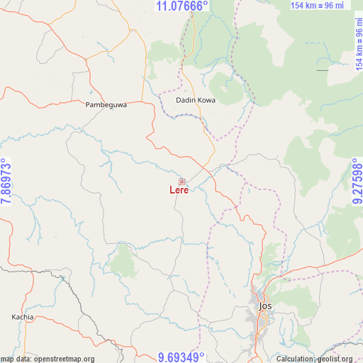
| Upper-left | 11.07666°, | 7.86973° |
| Center: | 10.38584°, | 8.57286° |
| Lower-right: | 9.69349°, | 9.27598° |
| Map W x H: | 153.8×153.8 km | = 95.6×95.6mi |
| max Lat: | 13.7543° ⇑32.3% North |
| Lere: | 10.38584° |
| min Lat: | ⇓67.7% South 4.31231° |
| min Long | Lere | max Long |
| 2.73333° | 8.57286° | 14.46552° |
| W 72.6%⇐ | ⇒27.4% E |
Elevation
Elevation of Lere is 753 m = 2470 ft, and this is 456.5 m = 1498 ft above average elevation for this country.
| Max E: |
1599 m = 5246 ft | 2.7% |
| Lere | 753 m 2470 ft | |
| Avg. | 296.5 m = 973 ft | |
Min E: |
2 m = 7 ft | 97.3% |
See also: Lere elevation on elevation.city.
Geographical zone
Lere is located in North Torrid zone (between Equator and Tropic of Cancer). Distance of Equator is 1154.8 km =717.6 mi to South.| Distance of | km | miles | from Lere |
|---|---|---|---|
| North Pole | 8852.3 | 5500.6 | to North |
| Arctic Circle | 6246.4 | 3881.3 | to North |
| Tropic Cancer | 1451.1 | 901.7 | to North |
| Equator | 1154.8 | 717.6 | to South |


Nearby cities:
15 places around Lere: (largest is in red/bold)
• Anchau
67.1 km =41.7 mi,  342°
342°
• Angware
73.2 km =45.5 mi,  126°
126°
• Bassa
52.6 km =32.7 mi,  159°
159°
• Bukuru
73.1 km =45.4 mi,  154°
154°
• Dutsen Wai
65.8 km =40.9 mi,  321°
321°
• Jos
61.7 km =38.3 mi, 145°
• Kaura
80.8 km =50.2 mi,  188°
188°
• Kauru
50.7 km =31.5 mi,  294°
294°
• Lame
73.2 km =45.5 mi,  85°
85°
• Ririwai
43.5 km =27 mi,  25°
25°
• Riyom
85.7 km =53.3 mi,  166°
166°
• Saminaka
12.9 km =8 mi,  76°
76°
• Toro
65.3 km =40.6 mi,  123°
123°
• Vom
76.8 km =47.7 mi, 161°
• Zonkwa
73.7 km =45.8 mi,  204°
204°
Sources, notices
• [Note1] Compared only with cities in Nigeria existing in our database
• [Src1] Map data: © OpenStreetMap contributors (CC-BY-SA)
• [Src2] Other city data from geonames.org with taken over terms of usage.
• [Src3] Geographical zone / Annual Mean Temperature by Robert A. Rohde @ Wikipedia
