Atan geodata
Atan (Ogun) is a seat of a second-order administrative division; located in Nigeria in Africa/Lagos (GMT+1) time zone. In our database, there are 451 cities with bigger population. Compared to other cities in Nigeria, 69.7% of cities are located further ↑North; 92.2% of cities are located further →East and 80.7% of cities have higher elevation than Atan. Note1


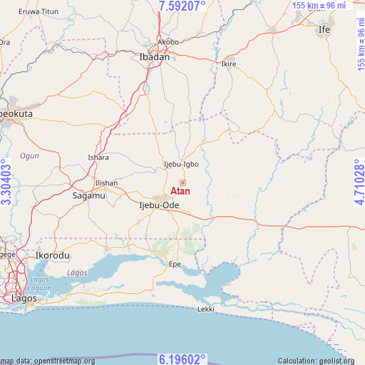
Atan GPS coordinates[2]
6° 53' 40.416" North, 4° 0' 25.74" East
| Map corner | latitude | longitude |
|---|---|---|
| Upper-left | 7.59207°, | 3.30403° |
| Center: | 6.89456°, | 4.00715° |
| Lower-right: | 6.19602°, | 4.71028° |
| Map W x H: | 155.2×155.2 km | = 96.4×96.4mi |
| max Lat: | 13.7543° ⇑69.7% North |
| Atan: | 6.89456° |
| min Lat: | ⇓30.3% South 4.31231° |
| min Long | Atan | max Long |
| 2.73333° | 4.00715° | 14.46552° |
| W 7.8%⇐ | ⇒92.2% E |
Elevation
Elevation of Atan is 78 m = 256 ft, and this is 218.5 m = 717 ft below average elevation for this country.
| Max E: |
1599 m = 5246 ft | 80.7% |
| Avg. | 296.5 m = 973 ft | |
| Atan | 78 m = 256 ft | |
Min E: |
2 m = 7 ft | 19.3% |
See also: Nigeria elevation on elevation.city.
Geographical zone
Atan is located in North Torrid zone (between Equator and Tropic of Cancer). Distance of Equator is 766.6 km =476.3 mi to South.| Distance of | km | miles | from Atan |
|---|---|---|---|
| North Pole | 9240.5 | 5741.8 | to North |
| Arctic Circle | 6634.6 | 4122.5 | to North |
| Tropic Cancer | 1839.3 | 1142.9 | to North |
| Equator | 766.6 | 476.3 | to South |


Nearby cities:
15 places around Atan: (largest is in red/bold)
• Akanran
43 km =26.7 mi,  2°
2°
• Akodo
51.5 km =32 mi,  189°
189°
• Egbeda
53.9 km =33.5 mi,  5°
5°
• Ejirin
33.3 km =20.7 mi,  200°
200°
• Epe
34.6 km =21.5 mi,  184°
184°
• Idi-Ayunre
40.9 km =25.4 mi,  336°
336°
• Ijebu-Ife
13.3 km =8.3 mi,  167°
167°
• Ijebu-Igbo
8.7 km =5.4 mi,  354°
354°
• Ijebu-Ode
13 km =8.1 mi,  229°
229°
• Ikenne
32.4 km =20.1 mi,  264°
264°
• Iperu
37.7 km =23.4 mi,  272°
272°
• Isara
37.6 km =23.4 mi,  287°
287°
• Odogbolu
27.6 km =17.1 mi, 257°
• Ogbere
24.2 km =15 mi,  135°
135°
• Shagamu
40.2 km =25 mi, 262°
Sources, notices
• [Note1] Compared only with cities in Nigeria existing in our database
• [Src1] Map data: © OpenStreetMap contributors (CC-BY-SA)
• [Src2] Other city data from geonames.org with taken over terms of usage.
• [Src3] Geographical zone / Annual Mean Temperature by Robert A. Rohde @ Wikipedia
