Isara geodata
Isara (Ogun) is a seat of a second-order administrative division; located in Nigeria in Africa/Lagos (GMT+1) time zone. With population of 8,205 people, there are 378 cities with bigger population in this country. Compared to other cities in Nigeria, 68.4% of cities are located further ↑North; 94.4% of cities are located further →East and 72% of cities have higher elevation than Isara. Note1


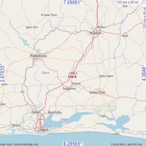
Isara GPS coordinates[2]
6° 59' 36.42" North, 3° 40' 53.328" East
| Map corner | latitude | longitude |
|---|---|---|
| Upper-left | 7.69081°, | 2.97835° |
| Center: | 6.99345°, | 3.68148° |
| Lower-right: | 6.29505°, | 4.3846° |
| Map W x H: | 155.2×155.2 km | = 96.4×96.4mi |
| max Lat: | 13.7543° ⇑68.4% North |
| Isara: | 6.99345° |
| min Lat: | ⇓31.6% South 4.31231° |
| min Long | Isara | max Long |
| 2.73333° | 3.68148° | 14.46552° |
| W 5.6%⇐ | ⇒94.4% E |
Elevation
Elevation of Isara is 138 m = 453 ft, and this is 158.5 m = 520 ft below average elevation for this country.
| Max E: |
1599 m = 5246 ft | 72% |
| Avg. | 296.5 m = 973 ft | |
| Isara | 138 m = 453 ft | |
Min E: |
2 m = 7 ft | 28% |
See also: Nigeria elevation on elevation.city.
Geographical zone
Isara is located in North Torrid zone (between Equator and Tropic of Cancer). Distance of Equator is 777.6 km =483.2 mi to South.| Distance of | km | miles | from Isara |
|---|---|---|---|
| North Pole | 9229.5 | 5734.9 | to North |
| Arctic Circle | 6623.6 | 4115.7 | to North |
| Tropic Cancer | 1828.3 | 1136.1 | to North |
| Equator | 777.6 | 483.2 | to South |


Nearby cities:
15 places around Isara: (largest is in red/bold)
• Abeokuta
41.3 km =25.7 mi,  295°
295°
• Atan
37.6 km =23.4 mi,  107°
107°
• Ebute Ikorodu
48.6 km =30.2 mi,  206°
206°
• Ejirin
48.6 km =30.2 mi,  150°
150°
• Idi-Ayunre
33.2 km =20.6 mi,  36°
36°
• Ijebu-Ife
45.7 km =28.4 mi,  121°
121°
• Ijebu-Igbo
35.2 km =21.9 mi,  93°
93°
• Ijebu-Ode
32.4 km =20.1 mi,  126°
126°
• Ikenne
14.7 km =9.1 mi,  165°
165°
• Ikorodu
46.3 km =28.8 mi,  204°
204°
• Iperu
9.4 km =5.8 mi,  190°
190°
• Odeda
31.5 km =19.6 mi,  327°
327°
• Odogbolu
19.2 km =11.9 mi, 152°
• Owode
20 km =12.4 mi,  255°
255°
• Shagamu
16.6 km =10.3 mi, 193°
Sources, notices
• [Note1] Compared only with cities in Nigeria existing in our database
• [Src1] Map data: © OpenStreetMap contributors (CC-BY-SA)
• [Src2] Other city data from geonames.org with taken over terms of usage.
• [Src3] Geographical zone / Annual Mean Temperature by Robert A. Rohde @ Wikipedia
