Ijebu-Ode geodata
Ijebu-Ode (Ogun) is a seat of a second-order administrative division; located in Nigeria in Africa/Lagos (GMT+1) time zone. With population of 209,175 people, there are 44 cities with bigger population in this country. Compared to other cities in Nigeria, 70.8% of cities are located further ↑North; 92.9% of cities are located further →East and 81.4% of cities have higher elevation than Ijebu-Ode. Note1


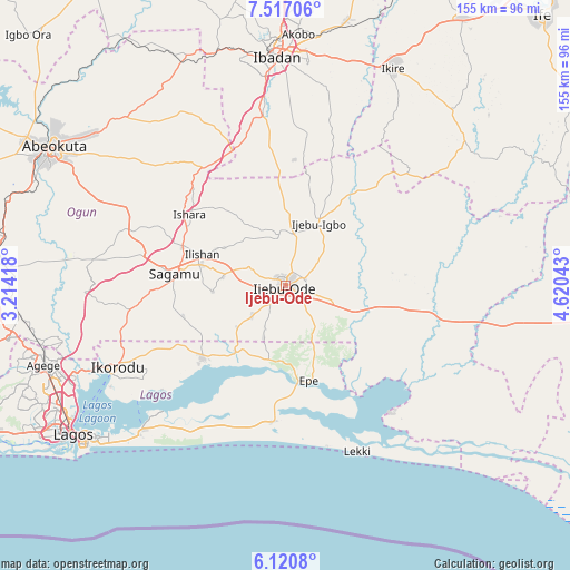
Ijebu-Ode GPS coordinates[2]
6° 49' 9.984" North, 3° 55' 2.316" East
| Map corner | latitude | longitude |
|---|---|---|
| Upper-left | 7.51706°, | 3.21418° |
| Center: | 6.81944°, | 3.91731° |
| Lower-right: | 6.1208°, | 4.62043° |
| Map W x H: | 155.2×155.3 km | = 96.4×96.5mi |
| max Lat: | 13.7543° ⇑70.8% North |
| Ijebu-Ode: | 6.81944° |
| min Lat: | ⇓29.2% South 4.31231° |
| min Long | Ijebu-Ode | max Long |
| 2.73333° | 3.91731° | 14.46552° |
| W 7.1%⇐ | ⇒92.9% E |
Elevation
Elevation of Ijebu-Ode is 74 m = 243 ft, and this is 222.5 m = 730 ft below average elevation for this country.
| Max E: |
1599 m = 5246 ft | 81.4% |
| Avg. | 296.5 m = 973 ft | |
| Ijebu-Ode | 74 m = 243 ft | |
Min E: |
2 m = 7 ft | 18.6% |
See also: Ijebu-Ode elevation on elevation.city.
Geographical zone
Ijebu-Ode is located in North Torrid zone (between Equator and Tropic of Cancer). Distance of Equator is 758.3 km =471.2 mi to South.| Distance of | km | miles | from Ijebu-Ode |
|---|---|---|---|
| North Pole | 9248.8 | 5746.9 | to North |
| Arctic Circle | 6642.9 | 4127.7 | to North |
| Tropic Cancer | 1847.7 | 1148.1 | to North |
| Equator | 758.3 | 471.2 | to South |


Nearby cities:
15 places around Ijebu-Ode: (largest is in red/bold)
• Akodo
42.5 km =26.4 mi,  177°
177°
• Atan
13 km =8.1 mi,  49°
49°
• Ejirin
22.9 km =14.2 mi, 184°
• Epe
27.2 km =16.9 mi,  164°
164°
• Idi-Ayunre
46.4 km =28.8 mi,  352°
352°
• Ijebu-Ife
13.7 km =8.5 mi,  109°
109°
• Ijebu-Igbo
19.2 km =11.9 mi,  28°
28°
• Ikenne
22.9 km =14.2 mi,  283°
283°
• Ikorodu
50.7 km =31.5 mi,  243°
243°
• Iperu
29.6 km =18.4 mi,  289°
289°
• Isara
32.4 km =20.1 mi,  306°
306°
• Odogbolu
17.2 km =10.7 mi, 277°
• Ogbere
28.3 km =17.6 mi, 108°
• Owode
47.7 km =29.6 mi, 287°
• Shagamu
30.1 km =18.7 mi, 276°
Sources, notices
• [Note1] Compared only with cities in Nigeria existing in our database
• [Src1] Map data: © OpenStreetMap contributors (CC-BY-SA)
• [Src2] Other city data from geonames.org with taken over terms of usage.
• [Src3] Geographical zone / Annual Mean Temperature by Robert A. Rohde @ Wikipedia
