Shagamu geodata
Shagamu (Ogun) is a seat of a second-order administrative division; located in Nigeria in Africa/Lagos (GMT+1) time zone. With population of 214,558 people, there are 43 cities with bigger population in this country. Compared to other cities in Nigeria, 70.5% of cities are located further ↑North; 94.7% of cities are located further →East and 86.1% of cities have higher elevation than Shagamu. Note1


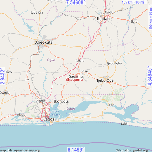
Shagamu GPS coordinates[2]
6° 50' 54.6" North, 3° 38' 46.788" East
| Map corner | latitude | longitude |
|---|---|---|
| Upper-left | 7.54608°, | 2.9432° |
| Center: | 6.8485°, | 3.64633° |
| Lower-right: | 6.1499°, | 4.34945° |
| Map W x H: | 155.2×155.2 km | = 96.4×96.4mi |
| max Lat: | 13.7543° ⇑70.5% North |
| Shagamu: | 6.8485° |
| min Lat: | ⇓29.5% South 4.31231° |
| min Long | Shagamu | max Long |
| 2.73333° | 3.64633° | 14.46552° |
| W 5.3%⇐ | ⇒94.7% E |
Elevation
Elevation of Shagamu is 53 m = 174 ft, and this is 243.5 m = 799 ft below average elevation for this country.
| Max E: |
1599 m = 5246 ft | 86.1% |
| Avg. | 296.5 m = 973 ft | |
| Shagamu | 53 m = 174 ft | |
Min E: |
2 m = 7 ft | 13.9% |
See also: Shagamu elevation on elevation.city.
Geographical zone
Shagamu is located in North Torrid zone (between Equator and Tropic of Cancer). Distance of Equator is 761.5 km =473.2 mi to South.| Distance of | km | miles | from Shagamu |
|---|---|---|---|
| North Pole | 9245.6 | 5744.9 | to North |
| Arctic Circle | 6639.7 | 4125.7 | to North |
| Tropic Cancer | 1844.4 | 1146.1 | to North |
| Equator | 761.5 | 473.2 | to South |


Nearby cities:
15 places around Shagamu: (largest is in red/bold)
• Agege
43.2 km =26.8 mi,  233°
233°
• Atan
40.2 km =25 mi,  82°
82°
• Ebute Ikorodu
32.6 km =20.3 mi,  212°
212°
• Ejirin
38.3 km =23.8 mi,  132°
132°
• Ifako
42.1 km =26.2 mi,  237°
237°
• Ijebu-Ife
43.5 km =27 mi,  100°
100°
• Ijebu-Igbo
41.3 km =25.7 mi,  70°
70°
• Ijebu-Ode
30.1 km =18.7 mi, 96°
• Ikenne
7.8 km =4.8 mi, 75°
• Ikorodu
30.2 km =18.8 mi, 210°
• Iperu
7.2 km =4.5 mi,  17°
17°
• Isara
16.6 km =10.3 mi,  13°
13°
• Odogbolu
12.9 km =8 mi,  94°
94°
• Ojota
41.5 km =25.8 mi,  223°
223°
• Owode
19.1 km =11.9 mi,  305°
305°
Sources, notices
• [Note1] Compared only with cities in Nigeria existing in our database
• [Src1] Map data: © OpenStreetMap contributors (CC-BY-SA)
• [Src2] Other city data from geonames.org with taken over terms of usage.
• [Src3] Geographical zone / Annual Mean Temperature by Robert A. Rohde @ Wikipedia
