Iperu geodata
Iperu (Ogun) is a populated place; located in Nigeria in Africa/Lagos (GMT+1) time zone. With population of 15,935 people, there are 230 cities with bigger population in this country. Compared to other cities in Nigeria, 69.5% of cities are located further ↑North; 94.5% of cities are located further →East and 77.5% of cities have higher elevation than Iperu. Note1


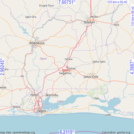
Iperu GPS coordinates[2]
6° 54' 36.072" North, 3° 39' 56.052" East
| Map corner | latitude | longitude |
|---|---|---|
| Upper-left | 7.60751°, | 2.96245° |
| Center: | 6.91002°, | 3.66557° |
| Lower-right: | 6.2115°, | 4.3687° |
| Map W x H: | 155.2×155.2 km | = 96.4×96.4mi |
| max Lat: | 13.7543° ⇑69.5% North |
| Iperu: | 6.91002° |
| min Lat: | ⇓30.5% South 4.31231° |
| min Long | Iperu | max Long |
| 2.73333° | 3.66557° | 14.46552° |
| W 5.5%⇐ | ⇒94.5% E |
Elevation
Elevation of Iperu is 97 m = 318 ft, and this is 199.5 m = 655 ft below average elevation for this country.
| Max E: |
1599 m = 5246 ft | 77.5% |
| Avg. | 296.5 m = 973 ft | |
| Iperu | 97 m = 318 ft | |
Min E: |
2 m = 7 ft | 22.5% |
See also: Nigeria elevation on elevation.city.
Geographical zone
Iperu is located in North Torrid zone (between Equator and Tropic of Cancer). Distance of Equator is 768.3 km =477.4 mi to South.| Distance of | km | miles | from Iperu |
|---|---|---|---|
| North Pole | 9238.7 | 5740.7 | to North |
| Arctic Circle | 6632.9 | 4121.5 | to North |
| Tropic Cancer | 1837.6 | 1141.8 | to North |
| Equator | 768.3 | 477.4 | to South |


Nearby cities:
15 places around Iperu: (largest is in red/bold)
• Abeokuta
44.7 km =27.8 mi,  307°
307°
• Atan
37.7 km =23.4 mi,  92°
92°
• Ebute Ikorodu
39.6 km =24.6 mi,  209°
209°
• Ejirin
41.9 km =26 mi,  141°
141°
• Idi-Ayunre
41.9 km =26 mi,  31°
31°
• Ijebu-Ife
43.2 km =26.8 mi,  109°
109°
• Ijebu-Igbo
37.5 km =23.3 mi,  79°
79°
• Ijebu-Ode
29.6 km =18.4 mi, 109°
• Ikenne
7.4 km =4.6 mi,  131°
131°
• Ikorodu
37.2 km =23.1 mi, 208°
• Isara
9.4 km =5.8 mi,  10°
10°
• Odeda
38.9 km =24.2 mi,  337°
337°
• Odogbolu
13.2 km =8.2 mi, 125°
• Owode
18.2 km =11.3 mi,  283°
283°
• Shagamu
7.2 km =4.5 mi,  197°
197°
Sources, notices
• [Note1] Compared only with cities in Nigeria existing in our database
• [Src1] Map data: © OpenStreetMap contributors (CC-BY-SA)
• [Src2] Other city data from geonames.org with taken over terms of usage.
• [Src3] Geographical zone / Annual Mean Temperature by Robert A. Rohde @ Wikipedia
