Ijebu-Igbo geodata
Ijebu-Igbo (Ogun) is a seat of a second-order administrative division; located in Nigeria in Africa/Lagos (GMT+1) time zone. With population of 109,261 people, there are 79 cities with bigger population in this country. Compared to other cities in Nigeria, 68.7% of cities are located further ↑North; 92.3% of cities are located further →East and 77.8% of cities have higher elevation than Ijebu-Igbo. Note1


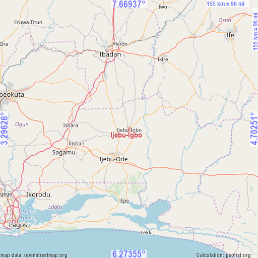
Ijebu-Igbo GPS coordinates[2]
6° 58' 19.128" North, 3° 59' 57.768" East
| Map corner | latitude | longitude |
|---|---|---|
| Upper-left | 7.66937°, | 3.29626° |
| Center: | 6.97198°, | 3.99938° |
| Lower-right: | 6.27355°, | 4.70251° |
| Map W x H: | 155.2×155.2 km | = 96.4×96.4mi |
| max Lat: | 13.7543° ⇑68.7% North |
| Ijebu-Igbo: | 6.97198° |
| min Lat: | ⇓31.3% South 4.31231° |
| min Long | Ijebu-Igbo | max Long |
| 2.73333° | 3.99938° | 14.46552° |
| W 7.7%⇐ | ⇒92.3% E |
Elevation
Elevation of Ijebu-Igbo is 94 m = 308 ft, and this is 202.5 m = 664 ft below average elevation for this country.
| Max E: |
1599 m = 5246 ft | 77.8% |
| Avg. | 296.5 m = 973 ft | |
| Ijebu-Igbo | 94 m = 308 ft | |
Min E: |
2 m = 7 ft | 22.2% |
See also: Ijebu-Igbo elevation on elevation.city.
Geographical zone
Ijebu-Igbo is located in North Torrid zone (between Equator and Tropic of Cancer). Distance of Equator is 775.2 km =481.7 mi to South.| Distance of | km | miles | from Ijebu-Igbo |
|---|---|---|---|
| North Pole | 9231.9 | 5736.4 | to North |
| Arctic Circle | 6626 | 4117.2 | to North |
| Tropic Cancer | 1830.7 | 1137.5 | to North |
| Equator | 775.2 | 481.7 | to South |


Nearby cities:
15 places around Ijebu-Igbo: (largest is in red/bold)
• Akanran
34.5 km =21.4 mi,  4°
4°
• Atan
8.7 km =5.4 mi,  174°
174°
• Egbeda
45.4 km =28.2 mi,  7°
7°
• Ejirin
41.3 km =25.7 mi,  195°
195°
• Epe
43.2 km =26.8 mi,  182°
182°
• Ibadan
46.3 km =28.8 mi,  347°
347°
• Idi-Ayunre
32.8 km =20.4 mi,  332°
332°
• Ijebu-Ife
21.9 km =13.6 mi, 169°
• Ijebu-Ode
19.2 km =11.9 mi,  208°
208°
• Ikenne
33.5 km =20.8 mi,  249°
249°
• Iperu
37.5 km =23.3 mi,  259°
259°
• Isara
35.2 km =21.9 mi,  273°
273°
• Odogbolu
29.9 km =18.6 mi,  240°
240°
• Ogbere
31.4 km =19.5 mi,  145°
145°
• Shagamu
41.3 km =25.7 mi, 250°
Sources, notices
• [Note1] Compared only with cities in Nigeria existing in our database
• [Src1] Map data: © OpenStreetMap contributors (CC-BY-SA)
• [Src2] Other city data from geonames.org with taken over terms of usage.
• [Src3] Geographical zone / Annual Mean Temperature by Robert A. Rohde @ Wikipedia
