La Libertad geodata
La Libertad (Chontales) is a seat of a second-order administrative division; located in Nicaragua in America/Managua (GMT-6) time zone. With population of 3,127 people, there are 92 cities with bigger population in this country. Compared to other cities in Nicaragua, 64.1% of cities are located further ↑North; 81.4% of cities are located further ←West and 68.9% of cities have lower elevation than La Libertad. Note1


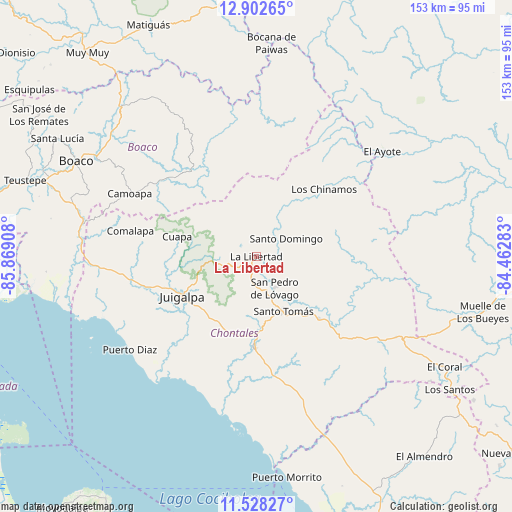
La Libertad GPS coordinates[2]
12° 12' 58.86" North, 85° 9' 57.42" West
| Map corner | latitude | longitude |
|---|---|---|
| Upper-left | 12.90265°, | -85.86908° |
| Center: | 12.21635°, | -85.16595° |
| Lower-right: | 11.52827°, | -84.46283° |
| Map W x H: | 152.8×152.8 km | = 94.9×94.9mi |
| max Lat: | 14.74189° ⇑64.1% North |
| La Libertad: | 12.21635° |
| min Lat: | ⇓35.9% South 10.94684° |
| min Long | La Libertad | max Long |
| -87.4516° | -85.16595° | -83.06145° |
| W 81.4%⇐ | ⇒18.6% E |
Elevation
Elevation of La Libertad is 483 m = 1585 ft, and this is 145.8 m = 478 ft above average elevation for this country.
| Max E: |
1288 m = 4226 ft | 31.1% |
| La Libertad | 483 m 1585 ft | |
| Avg. | 337.2 m = 1106 ft | |
Min E: |
1 m = 3 ft | 68.9% |
See also: Nicaragua elevation on elevation.city.
Geographical zone
La Libertad is located in North Torrid zone (between Equator and Tropic of Cancer). Distance of this Northern Tropic circle is 1247.6 km =775.2 mi to North.| Distance of | km | miles | from La Libertad |
|---|---|---|---|
| North Pole | 8648.7 | 5374.1 | to North |
| Arctic Circle | 6042.8 | 3754.8 | to North |
| Tropic Cancer | 1247.6 | 775.2 | to North |
| Equator | 1358.3 | 844 | to South |


Nearby cities:
15 places around La Libertad: (largest is in red/bold)
• Acoyapa
27.4 km =17 mi,  181°
181°
• Boaco
60.6 km =37.7 mi,  297°
297°
• Bocana de Paiwas
63.5 km =39.5 mi,  4°
4°
• Camoapa
42 km =26.1 mi, 296°
• Comalapa
38.2 km =23.7 mi,  281°
281°
• Cuapa
24.2 km =15 mi, 283°
• El Ayote
13.5 km =8.4 mi,  257°
257°
• El Ayote
49.4 km =30.7 mi,  50°
50°
• El Coral
65.3 km =40.6 mi,  120°
120°
• Juigalpa
24.8 km =15.4 mi,  240°
240°
• San Lorenzo
57.3 km =35.6 mi,  288°
288°
• San Pedro de Lóvago
11.1 km =6.9 mi,  150°
150°
• Santo Domingo
10.5 km =6.5 mi,  59°
59°
• Santo Tomás
18.3 km =11.4 mi, 153°
• Villa Sandino
26.5 km =16.5 mi,  134°
134°
Sources, notices
• [Note1] Compared only with cities in Nicaragua existing in our database
• [Src1] Map data: © OpenStreetMap contributors (CC-BY-SA)
• [Src2] Other city data from geonames.org with taken over terms of usage.
• [Src3] Geographical zone / Annual Mean Temperature by Robert A. Rohde @ Wikipedia
