El Ayote geodata
El Ayote (South Caribbean Coast) is a seat of a second-order administrative division; located in Nicaragua in America/Managua (GMT-6) time zone. In our database, there are 137 cities with bigger population. Compared to other cities in Nicaragua, 55.1% of cities are located further ↑North; 87.4% of cities are located further ←West and 61.7% of cities have higher elevation than El Ayote. Note1


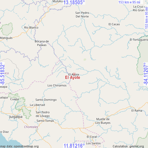
El Ayote GPS coordinates[2]
12° 29' 58.272" North, 84° 48' 54.684" West
| Map corner | latitude | longitude |
|---|---|---|
| Upper-left | 13.18505°, | -85.51832° |
| Center: | 12.49952°, | -84.81519° |
| Lower-right: | 11.81216°, | -84.11207° |
| Map W x H: | 152.7×152.7 km | = 94.9×94.9mi |
| max Lat: | 14.74189° ⇑55.1% North |
| El Ayote: | 12.49952° |
| min Lat: | ⇓44.9% South 10.94684° |
| min Long | El Ayote | max Long |
| -87.4516° | -84.81519° | -83.06145° |
| W 87.4%⇐ | ⇒12.6% E |
Elevation
Elevation of El Ayote is 138 m = 453 ft, and this is 199.2 m = 654 ft below average elevation for this country.
| Max E: |
1288 m = 4226 ft | 61.7% |
| Avg. | 337.2 m = 1106 ft | |
| El Ayote | 138 m = 453 ft | |
Min E: |
1 m = 3 ft | 38.3% |
See also: Nicaragua elevation on elevation.city.
Geographical zone
El Ayote is located in North Torrid zone (between Equator and Tropic of Cancer). Distance of this Northern Tropic circle is 1216.1 km =755.6 mi to North.| Distance of | km | miles | from El Ayote |
|---|---|---|---|
| North Pole | 8617.2 | 5354.5 | to North |
| Arctic Circle | 6011.4 | 3735.3 | to North |
| Tropic Cancer | 1216.1 | 755.6 | to North |
| Equator | 1389.8 | 863.6 | to South |


Nearby cities:
15 places around El Ayote: (largest is in red/bold)
• Acoyapa
70.4 km =43.7 mi,  213°
213°
• Bocana de Paiwas
46.1 km =28.6 mi,  313°
313°
• Cuapa
66.7 km =41.4 mi,  247°
247°
• El Ayote
61.7 km =38.3 mi,  236°
236°
• El Coral
67.2 km =41.8 mi,  164°
164°
• El Rama
74.9 km =46.5 mi,  120°
120°
• El Tortuguero
76.1 km =47.3 mi,  61°
61°
• Juigalpa
74 km =46 mi,  233°
233°
• La Libertad
49.4 km =30.7 mi, 230°
• Muelle de los Bueyes
56.6 km =35.2 mi,  147°
147°
• Río Blanco
65.6 km =40.8 mi,  317°
317°
• San Pedro de Lóvago
52.5 km =32.6 mi,  218°
218°
• Santo Domingo
39.1 km =24.3 mi, 227°
• Santo Tomás
56.4 km =35 mi, 212°
• Villa Sandino
53.8 km =33.4 mi,  201°
201°
Sources, notices
• [Note1] Compared only with cities in Nicaragua existing in our database
• [Src1] Map data: © OpenStreetMap contributors (CC-BY-SA)
• [Src2] Other city data from geonames.org with taken over terms of usage.
• [Src3] Geographical zone / Annual Mean Temperature by Robert A. Rohde @ Wikipedia
