El Almendro geodata
El Almendro (Río San Juan) is a seat of a second-order administrative division; located in Nicaragua in America/Managua (GMT-6) time zone. With population of 2,681 people, there are 97 cities with bigger population in this country. Compared to other cities in Nicaragua, 90.4% of cities are located further ↑North; 89.2% of cities are located further ←West and 57.5% of cities have higher elevation than El Almendro. Note1


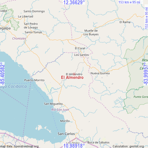
El Almendro GPS coordinates[2]
11° 40' 42.924" North, 84° 42' 9.684" West
| Map corner | latitude | longitude |
|---|---|---|
| Upper-left | 12.36629°, | -85.40582° |
| Center: | 11.67859°, | -84.70269° |
| Lower-right: | 10.98918°, | -83.99957° |
| Map W x H: | 153.1×153.1 km | = 95.1×95.1mi |
| max Lat: | 14.74189° ⇑90.4% North |
| El Almendro: | 11.67859° |
| min Lat: | ⇓9.6% South 10.94684° |
| min Long | El Almendro | max Long |
| -87.4516° | -84.70269° | -83.06145° |
| W 89.2%⇐ | ⇒10.8% E |
Elevation
Elevation of El Almendro is 175 m = 574 ft, and this is 162.2 m = 532 ft below average elevation for this country.
| Max E: |
1288 m = 4226 ft | 57.5% |
| Avg. | 337.2 m = 1106 ft | |
| El Almendro | 175 m = 574 ft | |
Min E: |
1 m = 3 ft | 42.5% |
See also: Nicaragua elevation on elevation.city.
Geographical zone
El Almendro is located in North Torrid zone (between Equator and Tropic of Cancer). Distance of Equator is 1298.5 km =806.9 mi to South.| Distance of | km | miles | from El Almendro |
|---|---|---|---|
| North Pole | 8708.5 | 5411.2 | to North |
| Arctic Circle | 6102.6 | 3792 | to North |
| Tropic Cancer | 1307.4 | 812.4 | to North |
| Equator | 1298.5 | 806.9 | to South |


Nearby cities:
15 places around El Almendro: (largest is in red/bold)
• Acoyapa
60.4 km =37.5 mi,  302°
302°
• Boca de Sábalos
74.5 km =46.3 mi,  159°
159°
• El Castillo de La Concepción
80.6 km =50.1 mi, 155°
• El Coral
27.3 km =17 mi,  12°
12°
• El Rama
75 km =46.6 mi,  44°
44°
• La Libertad
78.2 km =48.6 mi,  319°
319°
• Morrito
41.6 km =25.8 mi,  261°
261°
• Muelle de los Bueyes
47.2 km =29.3 mi,  22°
22°
• Nueva Guinea
26.9 km =16.7 mi,  87°
87°
• San Carlos
62.3 km =38.7 mi,  187°
187°
• San Miguelito
37.5 km =23.3 mi,  214°
214°
• San Pedro de Lóvago
67.3 km =41.8 mi, 318°
• Santo Domingo
77.1 km =47.9 mi,  327°
327°
• Santo Tomás
60.6 km =37.7 mi, 315°
• Villa Sandino
51.9 km =32.2 mi, 322°
Sources, notices
• [Note1] Compared only with cities in Nicaragua existing in our database
• [Src1] Map data: © OpenStreetMap contributors (CC-BY-SA)
• [Src2] Other city data from geonames.org with taken over terms of usage.
• [Src3] Geographical zone / Annual Mean Temperature by Robert A. Rohde @ Wikipedia
