Morrito geodata
Morrito (Río San Juan) is a seat of a second-order administrative division; located in Nicaragua in America/Managua (GMT-6) time zone. With population of 1,360 people, there are 120 cities with bigger population in this country. Compared to other cities in Nicaragua, 91% of cities are located further ↑North; 85% of cities are located further ←West and 88.6% of cities have higher elevation than Morrito. Note1


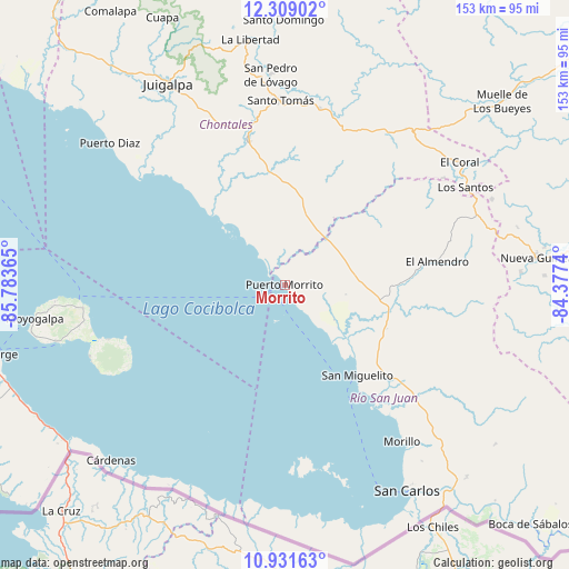
Morrito GPS coordinates[2]
11° 37' 16.248" North, 85° 4' 49.872" West
| Map corner | latitude | longitude |
|---|---|---|
| Upper-left | 12.30902°, | -85.78365° |
| Center: | 11.62118°, | -85.08052° |
| Lower-right: | 10.93163°, | -84.3774° |
| Map W x H: | 153.2×153.2 km | = 95.2×95.2mi |
| max Lat: | 14.74189° ⇑91% North |
| Morrito: | 11.62118° |
| min Lat: | ⇓9% South 10.94684° |
| min Long | Morrito | max Long |
| -87.4516° | -85.08052° | -83.06145° |
| W 85%⇐ | ⇒15% E |
Elevation
Elevation of Morrito is 37 m = 121 ft, and this is 300.2 m = 985 ft below average elevation for this country.
| Max E: |
1288 m = 4226 ft | 88.6% |
| Avg. | 337.2 m = 1106 ft | |
| Morrito | 37 m = 121 ft | |
Min E: |
1 m = 3 ft | 11.4% |
See also: Nicaragua elevation on elevation.city.
Geographical zone
Morrito is located in North Torrid zone (between Equator and Tropic of Cancer). Distance of Equator is 1292.2 km =802.9 mi to South.| Distance of | km | miles | from Morrito |
|---|---|---|---|
| North Pole | 8714.9 | 5415.2 | to North |
| Arctic Circle | 6109 | 3796 | to North |
| Tropic Cancer | 1313.8 | 816.4 | to North |
| Equator | 1292.2 | 802.9 | to South |


Nearby cities:
15 places around Morrito: (largest is in red/bold)
• Acoyapa
40 km =24.9 mi,  345°
345°
• Altagracia
54.6 km =33.9 mi,  263°
263°
• Cárdenas
66.4 km =41.3 mi,  224°
224°
• El Almendro
41.6 km =25.8 mi,  81°
81°
• El Ayote
67.2 km =41.8 mi,  340°
340°
• El Coral
57.5 km =35.7 mi,  54°
54°
• Juigalpa
62.2 km =38.6 mi,  330°
330°
• La Libertad
66.8 km =41.5 mi, 352°
• Moyogalpa
67.9 km =42.2 mi, 262°
• Nueva Guinea
68.4 km =42.5 mi, 83°
• San Carlos
64.4 km =40 mi,  149°
149°
• San Miguelito
31.3 km =19.4 mi,  141°
141°
• San Pedro de Lóvago
56.6 km =35.2 mi,  356°
356°
• Santo Tomás
49.8 km =30.9 mi, 358°
• Villa Sandino
48.4 km =30.1 mi,  11°
11°
Sources, notices
• [Note1] Compared only with cities in Nicaragua existing in our database
• [Src1] Map data: © OpenStreetMap contributors (CC-BY-SA)
• [Src2] Other city data from geonames.org with taken over terms of usage.
• [Src3] Geographical zone / Annual Mean Temperature by Robert A. Rohde @ Wikipedia
