El Rama geodata
El Rama (South Caribbean Coast) is a seat of a second-order administrative division; located in Nicaragua in America/Managua (GMT-6) time zone. With population of 20,456 people, there are 28 cities with bigger population in this country. Compared to other cities in Nicaragua, 66.5% of cities are located further ↑North; 93.4% of cities are located further ←West and 93.4% of cities have higher elevation than El Rama. Note1


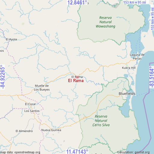
El Rama GPS coordinates[2]
12° 9' 34.74" North, 84° 13' 10.272" West
| Map corner | latitude | longitude |
|---|---|---|
| Upper-left | 12.8461°, | -84.92265° |
| Center: | 12.15965°, | -84.21952° |
| Lower-right: | 11.47143°, | -83.5164° |
| Map W x H: | 152.8×152.9 km | = 94.9×95mi |
| max Lat: | 14.74189° ⇑66.5% North |
| El Rama: | 12.15965° |
| min Lat: | ⇓33.5% South 10.94684° |
| min Long | El Rama | max Long |
| -87.4516° | -84.21952° | -83.06145° |
| W 93.4%⇐ | ⇒6.6% E |
Elevation
Elevation of El Rama is 14 m = 46 ft, and this is 323.2 m = 1060 ft below average elevation for this country.
| Max E: |
1288 m = 4226 ft | 93.4% |
| Avg. | 337.2 m = 1106 ft | |
| El Rama | 14 m = 46 ft | |
Min E: |
1 m = 3 ft | 6.6% |
See also: Nicaragua elevation on elevation.city.
Geographical zone
El Rama is located in North Torrid zone (between Equator and Tropic of Cancer). Distance of this Northern Tropic circle is 1253.9 km =779.1 mi to North.| Distance of | km | miles | from El Rama |
|---|---|---|---|
| North Pole | 8655 | 5378 | to North |
| Arctic Circle | 6049.1 | 3758.7 | to North |
| Tropic Cancer | 1253.9 | 779.1 | to North |
| Equator | 1352 | 840.1 | to South |


Nearby cities:
15 places around El Rama: (largest is in red/bold)
• Acoyapa
105.6 km =65.6 mi,  258°
258°
• Bluefields
52.2 km =32.4 mi,  108°
108°
• El Almendro
75 km =46.6 mi,  224°
224°
• El Ayote
74.9 km =46.5 mi,  300°
300°
• El Coral
53.8 km =33.4 mi,  240°
240°
• El Tortuguero
73.7 km =45.8 mi,  1°
1°
• Kukrahill
52.3 km =32.5 mi,  80°
80°
• La Libertad
103.1 km =64.1 mi,  273°
273°
• Laguna de Perlas
63 km =39.1 mi,  71°
71°
• Muelle de los Bueyes
35.7 km =22.2 mi,  253°
253°
• Nueva Guinea
58.5 km =36.4 mi,  206°
206°
• San Pedro de Lóvago
97.4 km =60.5 mi, 268°
• Santo Domingo
94.5 km =58.7 mi,  277°
277°
• Santo Tomás
95.2 km =59.2 mi, 263°
• Villa Sandino
85.1 km =52.9 mi, 261°
Sources, notices
• [Note1] Compared only with cities in Nicaragua existing in our database
• [Src1] Map data: © OpenStreetMap contributors (CC-BY-SA)
• [Src2] Other city data from geonames.org with taken over terms of usage.
• [Src3] Geographical zone / Annual Mean Temperature by Robert A. Rohde @ Wikipedia
