Randenbroek geodata
Randenbroek (Utrecht) is a section of populated place; located in Netherlands in Europe/Amsterdam (GMT+2) time zone. With population of 7,131 people, there are 360 cities with bigger population in this country. Compared to other cities in Netherlands, 56.9% of cities are located further ↓South; 60.5% of cities are located further →East and 50.6% of cities have higher elevation than Randenbroek. Note1


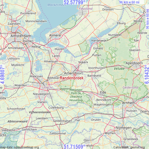
Randenbroek GPS coordinates[2]
52° 8' 55.068" North, 5° 24' 4.32" East
| Map corner | latitude | longitude |
|---|---|---|
| Upper-left | 52.57799°, | 4.69807° |
| Center: | 52.14863°, | 5.4012° |
| Lower-right: | 51.71509°, | 6.10432° |
| Map W x H: | 95.9×95.9 km | = 59.6×59.6mi |
| max Lat: | 53.48025° ⇑43.1% North |
| Randenbroek: | 52.14863° |
| min Lat: | ⇓56.9% South 50.76917° |
| min Long | Randenbroek | max Long |
| 3.38611° | 5.4012° | 7.16528° |
| W 39.5%⇐ | ⇒60.5% E |
Elevation
Elevation of Randenbroek is 6 m = 20 ft, and this is 9 m = 30 ft below average elevation for this country.
| Max E: |
203 m = 666 ft | 50.6% |
| Avg. | 15 m = 49 ft | |
| Randenbroek | 6 m = 20 ft | |
Min E: |
-6 m = -20 ft | 49.4% |
See also: Netherlands elevation on elevation.city.
Geographical zone
Randenbroek is located in North temperate zone (between Tropic of Cancer and the Arctic Circle). Distance of this North polar circle is 1602.8 km =995.9 mi to North.| Distance of | km | miles | from Randenbroek |
|---|---|---|---|
| North Pole | 4208.7 | 2615.2 | to North |
| Arctic Circle | 1602.8 | 995.9 | to North |
| Tropic Cancer | 3192.5 | 1983.7 | to South |
| Equator | 5798.4 | 3603 | to South |


Nearby cities:
15 places around Randenbroek: (largest is in red/bold)
• Amersfoort
1.2 km =0.7 mi,  307°
307°
• Austerlitz
9.6 km =6 mi,  217°
217°
• Corlaer
8.7 km =5.4 mi,  30°
30°
• Doornsteeg
9.7 km =6 mi,  21°
21°
• Hoogland
4.2 km =2.6 mi,  333°
333°
• Langenoord
4.6 km =2.9 mi,  341°
341°
• Leusden
2.8 km =1.7 mi,  130°
130°
• Maarn
9.6 km =6 mi,  192°
192°
• Nijkerkerveen
6.8 km =4.2 mi,  40°
40°
• Soest
8 km =5 mi,  290°
290°
• Soestdijk
9.2 km =5.7 mi,  300°
300°
• Sterrenberg
9 km =5.6 mi,  244°
244°
• Terschuur
8.1 km =5 mi,  76°
76°
• Woudenberg
7.6 km =4.7 mi,  172°
172°
• Zwartebroek
7.8 km =4.8 mi,  64°
64°
Sources, notices
• [Note1] Compared only with cities in Netherlands existing in our database
• [Src1] Map data: © OpenStreetMap contributors (CC-BY-SA)
• [Src2] Other city data from geonames.org with taken over terms of usage.
• [Src3] Geographical zone / Annual Mean Temperature by Robert A. Rohde @ Wikipedia
