Achtmaal geodata
Achtmaal (North Brabant) is a populated place; located in Netherlands in Europe/Amsterdam (GMT+2) time zone. With population of 635 people, there are 1680 cities with bigger population in this country. Compared to other cities in Netherlands, 83.7% of cities are located further ↑North; 86.8% of cities are located further →East and 67% of cities have lower elevation than Achtmaal. Note1


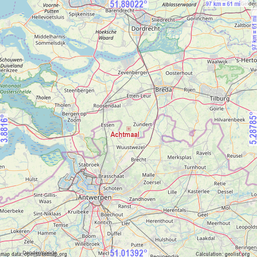
Achtmaal GPS coordinates[2]
51° 27' 15.012" North, 4° 35' 4.992" East
| Map corner | latitude | longitude |
|---|---|---|
| Upper-left | 51.89022°, | 3.8816° |
| Center: | 51.45417°, | 4.58472° |
| Lower-right: | 51.01392°, | 5.28785° |
| Map W x H: | 97.4×97.4 km | = 60.5×60.5mi |
| max Lat: | 53.48025° ⇑83.7% North |
| Achtmaal: | 51.45417° |
| min Lat: | ⇓16.3% South 50.76917° |
| min Long | Achtmaal | max Long |
| 3.38611° | 4.58472° | 7.16528° |
| W 13.2%⇐ | ⇒86.8% E |
Elevation
Elevation of Achtmaal is 13 m = 43 ft, and this is 2 m = 7 ft below average elevation for this country.
| Max E: |
203 m = 666 ft | 33% |
| Avg. | 15 m = 49 ft | |
| Achtmaal | 13 m = 43 ft | |
Min E: |
-6 m = -20 ft | 67% |
See also: Netherlands elevation on elevation.city.
Geographical zone
Achtmaal is located in North temperate zone (between Tropic of Cancer and the Arctic Circle). Distance of this North polar circle is 1680 km =1043.9 mi to North.| Distance of | km | miles | from Achtmaal |
|---|---|---|---|
| North Pole | 4285.9 | 2663.1 | to North |
| Arctic Circle | 1680 | 1043.9 | to North |
| Tropic Cancer | 3115.2 | 1935.7 | to South |
| Equator | 5721.2 | 3555 | to South |


Nearby cities:
15 places around Achtmaal: (largest is in red/bold)
• Bosschenhoofd
12.3 km =7.6 mi,  345°
345°
• Hoeven
13.9 km =8.6 mi,  359°
359°
• Hulsdonk
12.6 km =7.8 mi,  308°
308°
• Kalsdonk
12.3 km =7.6 mi,  320°
320°
• Klein-Zundert
5.7 km =3.5 mi,  58°
58°
• Nispen
9.1 km =5.7 mi,  290°
290°
• Rijsbergen
10.5 km =6.5 mi,  47°
47°
• Roosendaal
11.9 km =7.4 mi, 315°
• Rucphen
8.8 km =5.5 mi, 348°
• Schijf
5.3 km =3.3 mi,  341°
341°
• Sint Willebrord
10.5 km =6.5 mi,  1°
1°
• Sprundel
9.3 km =5.8 mi,  5°
5°
• Wernhout
3.9 km =2.4 mi,  88°
88°
• Zegge
12.3 km =7.6 mi, 337°
• Zundert
5.3 km =3.3 mi,  68°
68°
Sources, notices
• [Note1] Compared only with cities in Netherlands existing in our database
• [Src1] Map data: © OpenStreetMap contributors (CC-BY-SA)
• [Src2] Other city data from geonames.org with taken over terms of usage.
• [Src3] Geographical zone / Annual Mean Temperature by Robert A. Rohde @ Wikipedia
