Aagtdorp geodata
Aagtdorp (North Holland) is a populated place; located in Netherlands in Europe/Amsterdam (GMT+2) time zone. With population of 570 people, there are 1754 cities with bigger population in this country. Compared to other cities in Netherlands, 76.3% of cities are located further ↓South; 83% of cities are located further →East and 74.9% of cities have higher elevation than Aagtdorp. Note1


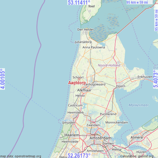
Aagtdorp GPS coordinates[2]
52° 41' 24" North, 4° 42' 15.012" East
| Map corner | latitude | longitude |
|---|---|---|
| Upper-left | 53.11411°, | 4.00105° |
| Center: | 52.69°, | 4.70417° |
| Lower-right: | 52.26173°, | 5.4073° |
| Map W x H: | 94.8×94.8 km | = 58.9×58.9mi |
| max Lat: | 53.48025° ⇑23.7% North |
| Aagtdorp: | 52.69° |
| min Lat: | ⇓76.3% South 50.76917° |
| min Long | Aagtdorp | max Long |
| 3.38611° | 4.70417° | 7.16528° |
| W 17%⇐ | ⇒83% E |
Elevation
Elevation of Aagtdorp is 2 m = 7 ft, and this is 13 m = 43 ft below average elevation for this country.
| Max E: |
203 m = 666 ft | 74.9% |
| Avg. | 15 m = 49 ft | |
| Aagtdorp | 2 m = 7 ft | |
Min E: |
-6 m = -20 ft | 25.1% |
See also: Netherlands elevation on elevation.city.
Geographical zone
Aagtdorp is located in North temperate zone (between Tropic of Cancer and the Arctic Circle). Distance of this North polar circle is 1542.6 km =958.5 mi to North.| Distance of | km | miles | from Aagtdorp |
|---|---|---|---|
| North Pole | 4148.5 | 2577.8 | to North |
| Arctic Circle | 1542.6 | 958.5 | to North |
| Tropic Cancer | 3252.7 | 2021.1 | to South |
| Equator | 5858.6 | 3640.4 | to South |


Nearby cities:
15 places around Aagtdorp: (largest is in red/bold)
• Alkmaar
7.1 km =4.4 mi,  155°
155°
• Bergen
2.3 km =1.4 mi,  180°
180°
• Broek op Langedijk
7.1 km =4.4 mi,  104°
104°
• Burgerbrug
6.5 km =4 mi,  359°
359°
• Dirkshorn
8.2 km =5.1 mi,  35°
35°
• Egmond aan Zee
9.3 km =5.8 mi,  213°
213°
• Harenkarspel
6.9 km =4.3 mi, 44°
• Heiloo
9.8 km =6.1 mi,  186°
186°
• Noord-Scharwoude
7.3 km =4.5 mi,  82°
82°
• Oudkarspel
7.4 km =4.6 mi,  67°
67°
• Petten
9 km =5.6 mi,  341°
341°
• Sint Maarten
9.6 km =6 mi,  17°
17°
• Sint Pancras
6.3 km =3.9 mi,  122°
122°
• Waarland
9.5 km =5.9 mi,  64°
64°
• Zuid-Scharwoude
7 km =4.3 mi,  93°
93°
Sources, notices
• [Note1] Compared only with cities in Netherlands existing in our database
• [Src1] Map data: © OpenStreetMap contributors (CC-BY-SA)
• [Src2] Other city data from geonames.org with taken over terms of usage.
• [Src3] Geographical zone / Annual Mean Temperature by Robert A. Rohde @ Wikipedia
