Bergen geodata
Bergen (North Holland) is a seat of a second-order administrative division; located in Netherlands in Europe/Amsterdam (GMT+2) time zone. In our database, there are 1836 cities with bigger population. Compared to other cities in Netherlands, 75.2% of cities are located further ↓South; 83% of cities are located further →East and 65.8% of cities have higher elevation than Bergen. Note1


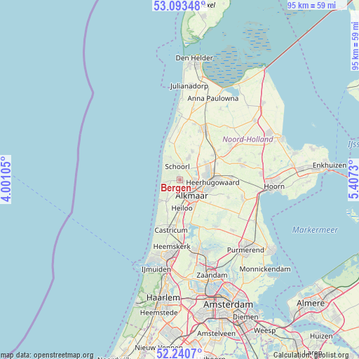
Bergen GPS coordinates[2]
52° 40' 9.012" North, 4° 42' 15.012" East
| Map corner | latitude | longitude |
|---|---|---|
| Upper-left | 53.09348°, | 4.00105° |
| Center: | 52.66917°, | 4.70417° |
| Lower-right: | 52.2407°, | 5.4073° |
| Map W x H: | 94.8×94.8 km | = 58.9×58.9mi |
| max Lat: | 53.48025° ⇑24.8% North |
| Bergen: | 52.66917° |
| min Lat: | ⇓75.2% South 50.76917° |
| min Long | Bergen | max Long |
| 3.38611° | 4.70417° | 7.16528° |
| W 17%⇐ | ⇒83% E |
Elevation
Elevation of Bergen is 3 m = 10 ft, and this is 12 m = 39 ft below average elevation for this country.
| Max E: |
203 m = 666 ft | 65.8% |
| Avg. | 15 m = 49 ft | |
| Bergen | 3 m = 10 ft | |
Min E: |
-6 m = -20 ft | 34.2% |
See also: Netherlands elevation on elevation.city.
Geographical zone
Bergen is located in North temperate zone (between Tropic of Cancer and the Arctic Circle). Distance of this North polar circle is 1544.9 km =960 mi to North.| Distance of | km | miles | from Bergen |
|---|---|---|---|
| North Pole | 4150.8 | 2579.2 | to North |
| Arctic Circle | 1544.9 | 960 | to North |
| Tropic Cancer | 3250.3 | 2019.6 | to South |
| Equator | 5856.3 | 3638.9 | to South |


Nearby cities:
15 places around Bergen: (largest is in red/bold)
• Aagtdorp
2.3 km =1.4 mi,  0°
0°
• Alkmaar
5.1 km =3.2 mi,  144°
144°
• Broek op Langedijk
6.9 km =4.3 mi,  85°
85°
• Burgerbrug
8.8 km =5.5 mi,  359°
359°
• Egmond aan Zee
7.5 km =4.7 mi,  223°
223°
• Egmond-Binnen
8.8 km =5.5 mi,  201°
201°
• Harenkarspel
8.7 km =5.4 mi,  34°
34°
• Heerhugowaard
9.7 km =6 mi, 88°
• Heiloo
7.5 km =4.7 mi,  188°
188°
• Noord-Scharwoude
7.9 km =4.9 mi,  65°
65°
• Oosterzij
9.4 km =5.8 mi,  179°
179°
• Oterleek
9.5 km =5.9 mi,  112°
112°
• Oudkarspel
8.6 km =5.3 mi,  52°
52°
• Sint Pancras
5.4 km =3.4 mi,  100°
100°
• Zuid-Scharwoude
7.3 km =4.5 mi, 74°
Sources, notices
• [Note1] Compared only with cities in Netherlands existing in our database
• [Src1] Map data: © OpenStreetMap contributors (CC-BY-SA)
• [Src2] Other city data from geonames.org with taken over terms of usage.
• [Src3] Geographical zone / Annual Mean Temperature by Robert A. Rohde @ Wikipedia
