Baak geodata
Baak (Gelderland) is a populated place; located in Netherlands in Europe/Amsterdam (GMT+2) time zone. With population of 575 people, there are 1747 cities with bigger population in this country. Compared to other cities in Netherlands, 53.3% of cities are located further ↓South; 83.9% of cities are located further ←West and 62% of cities have lower elevation than Baak. Note1


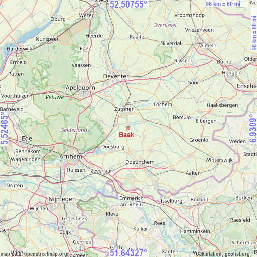
Baak GPS coordinates[2]
52° 4' 39" North, 6° 13' 40.008" East
| Map corner | latitude | longitude |
|---|---|---|
| Upper-left | 52.50755°, | 5.52465° |
| Center: | 52.0775°, | 6.22778° |
| Lower-right: | 51.64327°, | 6.9309° |
| Map W x H: | 96.1×96.1 km | = 59.7×59.7mi |
| max Lat: | 53.48025° ⇑46.7% North |
| Baak: | 52.0775° |
| min Lat: | ⇓53.3% South 50.76917° |
| min Long | Baak | max Long |
| 3.38611° | 6.22778° | 7.16528° |
| W 83.9%⇐ | ⇒16.1% E |
Elevation
Elevation of Baak is 11 m = 36 ft, and this is 4 m = 13 ft below average elevation for this country.
| Max E: |
203 m = 666 ft | 38% |
| Avg. | 15 m = 49 ft | |
| Baak | 11 m = 36 ft | |
Min E: |
-6 m = -20 ft | 62% |
See also: Netherlands elevation on elevation.city.
Geographical zone
Baak is located in North temperate zone (between Tropic of Cancer and the Arctic Circle). Distance of this North polar circle is 1610.7 km =1000.8 mi to North.| Distance of | km | miles | from Baak |
|---|---|---|---|
| North Pole | 4216.6 | 2620.1 | to North |
| Arctic Circle | 1610.7 | 1000.8 | to North |
| Tropic Cancer | 3184.6 | 1978.8 | to South |
| Equator | 5790.5 | 3598 | to South |


Nearby cities:
15 places around Baak: (largest is in red/bold)
• Brummen
5.1 km =3.2 mi,  285°
285°
• Dieren
9.2 km =5.7 mi,  252°
252°
• Doesburg
9.4 km =5.8 mi,  220°
220°
• Drempt
8.6 km =5.3 mi,  204°
204°
• Hengelo
6.3 km =3.9 mi,  117°
117°
• Hummelo
8.2 km =5.1 mi,  177°
177°
• Keijenborg
7 km =4.3 mi,  139°
139°
• Leesten
5.6 km =3.5 mi,  3°
3°
• Ooyerhoek
5.7 km =3.5 mi,  356°
356°
• Spankeren
8.2 km =5.1 mi, 254°
• Steenderen
3.1 km =1.9 mi,  241°
241°
• Vorden
6.4 km =4 mi,  61°
61°
• Warken
7.5 km =4.7 mi,  21°
21°
• Warnsveld
6.7 km =4.2 mi, 1°
• Zutphen
7 km =4.3 mi,  345°
345°
Sources, notices
• [Note1] Compared only with cities in Netherlands existing in our database
• [Src1] Map data: © OpenStreetMap contributors (CC-BY-SA)
• [Src2] Other city data from geonames.org with taken over terms of usage.
• [Src3] Geographical zone / Annual Mean Temperature by Robert A. Rohde @ Wikipedia
