Jevnaker geodata
Jevnaker (Oppland) is a seat of a second-order administrative division; located in Norway in Europe/Oslo (GMT+2) time zone. With population of 4,308 people, there are 102 cities with bigger population in this country. Compared to other cities in Norway, 58.9% of cities are located further ↑North; 55.5% of cities are located further ←West and 76.1% of cities have lower elevation than Jevnaker. Note1


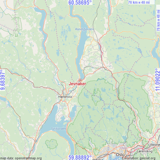
Jevnaker GPS coordinates[2]
60° 14' 23.244" North, 10° 23' 13.524" East
| Map corner | latitude | longitude |
|---|---|---|
| Upper-left | 60.58695°, | 9.68397° |
| Center: | 60.23979°, | 10.38709° |
| Lower-right: | 59.88892°, | 11.09022° |
| Map W x H: | 77.6×77.6 km | = 48.2×48.2mi |
| max Lat: | 71.04137° ⇑58.9% North |
| Jevnaker: | 60.23979° |
| min Lat: | ⇓41.1% South 58.0274° |
| min Long | Jevnaker | max Long |
| 4.71485° | 10.38709° | 31.11066° |
| W 55.5%⇐ | ⇒44.5% E |
Elevation
Elevation of Jevnaker is 150 m = 492 ft, and this is 45.8 m = 150 ft above average elevation for this country.
| Max E: |
897 m = 2943 ft | 23.9% |
| Jevnaker | 150 m 492 ft | |
| Avg. | 104.2 m = 342 ft | |
Min E: |
1 m = 3 ft | 76.1% |
See also: Norway elevation on elevation.city.
Geographical zone
Jevnaker is located in North temperate zone (between Tropic of Cancer and the Arctic Circle). Distance of this North polar circle is 703.1 km =436.9 mi to North.| Distance of | km | miles | from Jevnaker |
|---|---|---|---|
| North Pole | 3309 | 2056.1 | to North |
| Arctic Circle | 703.1 | 436.9 | to North |
| Tropic Cancer | 4092.1 | 2542.7 | to South |
| Equator | 6698 | 4161.9 | to South |


Nearby cities:
15 places around Jevnaker: (largest is in red/bold)
• Grua
15.3 km =9.5 mi,  82°
82°
• Hallingby
11.7 km =7.3 mi,  287°
287°
• Hønefoss
10.8 km =6.7 mi,  222°
222°
• Jaren
19.5 km =12.1 mi,  29°
29°
• Maura
35.6 km =22.1 mi,  86°
86°
• Roa
13.8 km =8.6 mi,  65°
65°
• Rotnes
33.2 km =20.6 mi,  127°
127°
• Skui
34.9 km =21.7 mi,  174°
174°
• Smestad
34.2 km =21.3 mi,  175°
175°
• Sokna
25.3 km =15.7 mi,  269°
269°
• Sundvollen
20.2 km =12.6 mi,  192°
192°
• Teigebyen
34.9 km =21.7 mi, 93°
• Tyristrand
23.5 km =14.6 mi, 223°
• Vik
19.1 km =11.9 mi,  198°
198°
• Åneby
31.5 km =19.6 mi,  122°
122°
Sources, notices
• [Note1] Compared only with cities in Norway existing in our database
• [Src1] Map data: © OpenStreetMap contributors (CC-BY-SA)
• [Src2] Other city data from geonames.org with taken over terms of usage.
• [Src3] Geographical zone / Annual Mean Temperature by Robert A. Rohde @ Wikipedia
