Hallingby geodata
Hallingby (Buskerud) is a populated place; located in Norway in Europe/Oslo (GMT+2) time zone. With population of 772 people, there are 362 cities with bigger population in this country. Compared to other cities in Norway, 57.4% of cities are located further ↑North; 50.5% of cities are located further ←West and 86.4% of cities have lower elevation than Hallingby. Note1


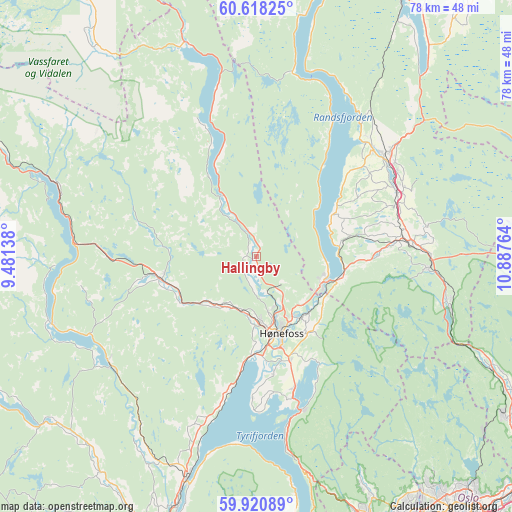
Hallingby GPS coordinates[2]
60° 16' 17.148" North, 10° 11' 4.236" East
| Map corner | latitude | longitude |
|---|---|---|
| Upper-left | 60.61825°, | 9.48138° |
| Center: | 60.27143°, | 10.18451° |
| Lower-right: | 59.92089°, | 10.88764° |
| Map W x H: | 77.5×77.5 km | = 48.2×48.2mi |
| max Lat: | 71.04137° ⇑57.4% North |
| Hallingby: | 60.27143° |
| min Lat: | ⇓42.6% South 58.0274° |
| min Long | Hallingby | max Long |
| 4.71485° | 10.18451° | 31.11066° |
| W 50.5%⇐ | ⇒49.5% E |
Elevation
Elevation of Hallingby is 220 m = 722 ft, and this is 115.8 m = 380 ft above average elevation for this country.
| Max E: |
897 m = 2943 ft | 13.6% |
| Hallingby | 220 m 722 ft | |
| Avg. | 104.2 m = 342 ft | |
Min E: |
1 m = 3 ft | 86.4% |
See also: Norway elevation on elevation.city.
Geographical zone
Hallingby is located in North temperate zone (between Tropic of Cancer and the Arctic Circle). Distance of this North polar circle is 699.6 km =434.7 mi to North.| Distance of | km | miles | from Hallingby |
|---|---|---|---|
| North Pole | 3305.5 | 2053.9 | to North |
| Arctic Circle | 699.6 | 434.7 | to North |
| Tropic Cancer | 4095.6 | 2544.9 | to South |
| Equator | 6701.6 | 4164.2 | to South |


Nearby cities:
15 places around Hallingby: (largest is in red/bold)
• Grua
26.4 km =16.4 mi,  93°
93°
• Hønefoss
12.2 km =7.6 mi,  160°
160°
• Jaren
24.7 km =15.3 mi,  56°
56°
• Jevnaker
11.7 km =7.3 mi,  107°
107°
• Noresund
32.6 km =20.3 mi,  251°
251°
• Prestfoss
39.6 km =24.6 mi,  230°
230°
• Roa
23.9 km =14.9 mi,  84°
84°
• Skui
40.9 km =25.4 mi, 159°
• Smestad
40 km =24.9 mi, 159°
• Sokna
14.6 km =9.1 mi,  255°
255°
• Sundvollen
24.2 km =15 mi, 163°
• Sylling
42.5 km =26.4 mi,  172°
172°
• Tyristrand
21.2 km =13.2 mi,  193°
193°
• Vik
22.2 km =13.8 mi, 166°
• Vikersund
35.4 km =22 mi,  197°
197°
Sources, notices
• [Note1] Compared only with cities in Norway existing in our database
• [Src1] Map data: © OpenStreetMap contributors (CC-BY-SA)
• [Src2] Other city data from geonames.org with taken over terms of usage.
• [Src3] Geographical zone / Annual Mean Temperature by Robert A. Rohde @ Wikipedia
