Myre geodata
Myre (Nordland) is a seat of a second-order administrative division; located in Norway in Europe/Oslo (GMT+2) time zone. With population of 1,994 people, there are 203 cities with bigger population in this country. Compared to other cities in Norway, 93.7% of cities are located further ↓South; 89.9% of cities are located further ←West and 69% of cities have higher elevation than Myre. Note1


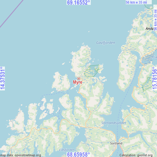
Myre GPS coordinates[2]
68° 54' 50.4" North, 15° 4' 42.348" East
| Map corner | latitude | longitude |
|---|---|---|
| Upper-left | 69.16552°, | 14.37531° |
| Center: | 68.914°, | 15.07843° |
| Lower-right: | 68.65958°, | 15.78156° |
| Map W x H: | 56.3×56.3 km | = 35×35mi |
| max Lat: | 71.04137° ⇑6.3% North |
| Myre: | 68.914° |
| min Lat: | ⇓93.7% South 58.0274° |
| min Long | Myre | max Long |
| 4.71485° | 15.07843° | 31.11066° |
| W 89.9%⇐ | ⇒10.1% E |
Elevation
Elevation of Myre is 20 m = 66 ft, and this is 84.2 m = 276 ft below average elevation for this country.
| Max E: |
897 m = 2943 ft | 69% |
| Avg. | 104.2 m = 342 ft | |
| Myre | 20 m = 66 ft | |
Min E: |
1 m = 3 ft | 31% |
See also: Norway elevation on elevation.city.
Geographical zone
Myre is located in North Frigid zone (between North Pole and Arctic Circle). Distance of this North polar circle is 261.3 km =162.4 mi to South.| Distance of | km | miles | from Myre |
|---|---|---|---|
| North Pole | 2344.5 | 1456.8 | to North |
| Arctic Circle | 261.3 | 162.4 | to South |
| Tropic Cancer | 5056.6 | 3142 | to South |
| Equator | 7662.5 | 4761.3 | to South |


Nearby cities:
15 places around Myre: (largest is in red/bold)
• Andenes
60.7 km =37.7 mi,  42°
42°
• Borkenes
46.6 km =29 mi,  109°
109°
• Evenskjer
70.6 km =43.9 mi,  121°
121°
• Harstad
60.1 km =37.3 mi,  102°
102°
• Hol
66.7 km =41.4 mi,  127°
127°
• Kabelvåg
82 km =51 mi,  197°
197°
• Lødingen
66.9 km =41.6 mi,  146°
146°
• Melbu
47.1 km =29.3 mi,  193°
193°
• Myre
41.2 km =25.6 mi,  58°
58°
• Sigerfjord
34.7 km =21.6 mi, 149°
• Sortland
27.6 km =17.1 mi, 151°
• Stokmarknes
39.4 km =24.5 mi, 189°
• Strand
28.3 km =17.6 mi, 148°
• Straume
34.9 km =21.7 mi,  224°
224°
• Svolvær
78.4 km =48.7 mi, 195°
Sources, notices
• [Note1] Compared only with cities in Norway existing in our database
• [Src1] Map data: © OpenStreetMap contributors (CC-BY-SA)
• [Src2] Other city data from geonames.org with taken over terms of usage.
• [Src3] Geographical zone / Annual Mean Temperature by Robert A. Rohde @ Wikipedia
