Spetalen geodata
Spetalen (Hedmark) is a populated place; located in Norway in Europe/Oslo (GMT+2) time zone. With population of 1,969 people, there are 206 cities with bigger population in this country. Compared to other cities in Norway, 60.3% of cities are located further ↑North; 80.4% of cities are located further ←West and 87.5% of cities have lower elevation than Spetalen. Note1


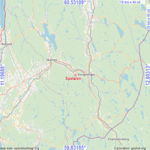
Spetalen GPS coordinates[2]
60° 10' 59.988" North, 11° 54' 0" East
| Map corner | latitude | longitude |
|---|---|---|
| Upper-left | 60.53109°, | 11.19688° |
| Center: | 60.18333°, | 11.9° |
| Lower-right: | 59.83185°, | 12.60313° |
| Map W x H: | 77.7×77.7 km | = 48.3×48.3mi |
| max Lat: | 71.04137° ⇑60.3% North |
| Spetalen: | 60.18333° |
| min Lat: | ⇓39.7% South 58.0274° |
| min Long | Spetalen | max Long |
| 4.71485° | 11.9° | 31.11066° |
| W 80.4%⇐ | ⇒19.6% E |
Elevation
Elevation of Spetalen is 230 m = 755 ft, and this is 125.8 m = 413 ft above average elevation for this country.
| Max E: |
897 m = 2943 ft | 12.5% |
| Spetalen | 230 m 755 ft | |
| Avg. | 104.2 m = 342 ft | |
Min E: |
1 m = 3 ft | 87.5% |
See also: Norway elevation on elevation.city.
Geographical zone
Spetalen is located in North temperate zone (between Tropic of Cancer and the Arctic Circle). Distance of this North polar circle is 709.4 km =440.8 mi to North.| Distance of | km | miles | from Spetalen |
|---|---|---|---|
| North Pole | 3315.3 | 2060 | to North |
| Arctic Circle | 709.4 | 440.8 | to North |
| Tropic Cancer | 4085.8 | 2538.8 | to South |
| Equator | 6691.8 | 4158.1 | to South |


Nearby cities:
15 places around Spetalen: (largest is in red/bold)
• Auli
34.2 km =21.3 mi,  241°
241°
• Aursmoen
38.1 km =23.7 mi,  221°
221°
• Fjellfoten
25.9 km =16.1 mi,  246°
246°
• Haga
32.5 km =20.2 mi, 243°
• Kirkenær
31.8 km =19.8 mi,  15°
15°
• Kongsvinger
5.5 km =3.4 mi,  81°
81°
• Magnor
30.8 km =19.1 mi,  147°
147°
• Neskollen
31.8 km =19.8 mi,  257°
257°
• Nordkisa
35.2 km =21.9 mi,  270°
270°
• Roverud
11.5 km =7.1 mi,  47°
47°
• Sand
30.5 km =19 mi,  319°
319°
• Skarnes
14.2 km =8.8 mi,  303°
303°
• Skotterud
25.6 km =15.9 mi, 150°
• Tomteråsen
30.6 km =19 mi, 253°
• Årnes
24.7 km =15.3 mi, 254°
Sources, notices
• [Note1] Compared only with cities in Norway existing in our database
• [Src1] Map data: © OpenStreetMap contributors (CC-BY-SA)
• [Src2] Other city data from geonames.org with taken over terms of usage.
• [Src3] Geographical zone / Annual Mean Temperature by Robert A. Rohde @ Wikipedia
