Sand geodata
Sand (Hedmark) is a seat of a second-order administrative division; located in Norway in Europe/Oslo (GMT+2) time zone. With population of 946 people, there are 325 cities with bigger population in this country. Compared to other cities in Norway, 54.9% of cities are located further ↑North; 78.3% of cities are located further ←West and 77.4% of cities have lower elevation than Sand. Note1


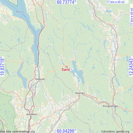
Sand GPS coordinates[2]
60° 23' 31.92" North, 11° 32' 25.08" East
| Map corner | latitude | longitude |
|---|---|---|
| Upper-left | 60.73774°, | 10.83718° |
| Center: | 60.3922°, | 11.5403° |
| Lower-right: | 60.04296°, | 12.24343° |
| Map W x H: | 77.3×77.2 km | = 48×48mi |
| max Lat: | 71.04137° ⇑54.9% North |
| Sand: | 60.3922° |
| min Lat: | ⇓45.1% South 58.0274° |
| min Long | Sand | max Long |
| 4.71485° | 11.5403° | 31.11066° |
| W 78.3%⇐ | ⇒21.7% E |
Elevation
Elevation of Sand is 160 m = 525 ft, and this is 55.8 m = 183 ft above average elevation for this country.
| Max E: |
897 m = 2943 ft | 22.6% |
| Sand | 160 m 525 ft | |
| Avg. | 104.2 m = 342 ft | |
Min E: |
1 m = 3 ft | 77.4% |
See also: Norway elevation on elevation.city.
Geographical zone
Sand is located in North temperate zone (between Tropic of Cancer and the Arctic Circle). Distance of this North polar circle is 686.2 km =426.4 mi to North.| Distance of | km | miles | from Sand |
|---|---|---|---|
| North Pole | 3292.1 | 2045.6 | to North |
| Arctic Circle | 686.2 | 426.4 | to North |
| Tropic Cancer | 4109.1 | 2553.3 | to South |
| Equator | 6715 | 4172.5 | to South |


Nearby cities:
15 places around Sand: (largest is in red/bold)
• Eidsvoll
16.7 km =10.4 mi,  246°
246°
• Hof
31.9 km =19.8 mi,  55°
55°
• Hurdal
26.4 km =16.4 mi,  280°
280°
• Kirkenær
29.4 km =18.3 mi,  75°
75°
• Kongsvinger
33.7 km =20.9 mi,  131°
131°
• Maura
31.7 km =19.7 mi,  241°
241°
• Neskollen
32.1 km =19.9 mi,  200°
200°
• Nordkisa
27.6 km =17.1 mi,  213°
213°
• Roverud
32.1 km =19.9 mi,  118°
118°
• Råholt
23.8 km =14.8 mi, 236°
• Sesvoll
25.9 km =16.1 mi,  232°
232°
• Skarnes
17.3 km =10.7 mi,  152°
152°
• Spetalen
30.5 km =19 mi,  139°
139°
• Tomteråsen
33.1 km =20.6 mi, 196°
• Årnes
30.3 km =18.8 mi,  187°
187°
Sources, notices
• [Note1] Compared only with cities in Norway existing in our database
• [Src1] Map data: © OpenStreetMap contributors (CC-BY-SA)
• [Src2] Other city data from geonames.org with taken over terms of usage.
• [Src3] Geographical zone / Annual Mean Temperature by Robert A. Rohde @ Wikipedia
