Kirkenær geodata
Kirkenær (Hedmark) is a seat of a second-order administrative division; located in Norway in Europe/Oslo (GMT+2) time zone. With population of 1,252 people, there are 262 cities with bigger population in this country. Compared to other cities in Norway, 53.2% of cities are located further ↑North; 81.6% of cities are located further ←West and 77.1% of cities have lower elevation than Kirkenær. Note1


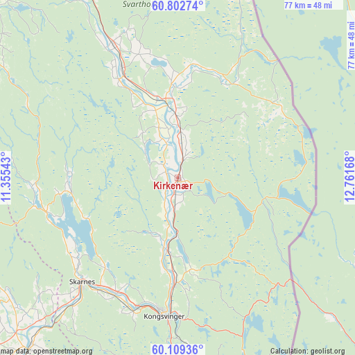
Kirkenær GPS coordinates[2]
60° 27' 28.44" North, 12° 3' 30.78" East
| Map corner | latitude | longitude |
|---|---|---|
| Upper-left | 60.80274°, | 11.35543° |
| Center: | 60.4579°, | 12.05855° |
| Lower-right: | 60.10936°, | 12.76168° |
| Map W x H: | 77.1×77.1 km | = 47.9×47.9mi |
| max Lat: | 71.04137° ⇑53.2% North |
| Kirkenær: | 60.4579° |
| min Lat: | ⇓46.8% South 58.0274° |
| min Long | Kirkenær | max Long |
| 4.71485° | 12.05855° | 31.11066° |
| W 81.6%⇐ | ⇒18.4% E |
Elevation
Elevation of Kirkenær is 157 m = 515 ft, and this is 52.8 m = 173 ft above average elevation for this country.
| Max E: |
897 m = 2943 ft | 22.9% |
| Kirkenær | 157 m 515 ft | |
| Avg. | 104.2 m = 342 ft | |
Min E: |
1 m = 3 ft | 77.1% |
See also: Norway elevation on elevation.city.
Geographical zone
Kirkenær is located in North temperate zone (between Tropic of Cancer and the Arctic Circle). Distance of this North polar circle is 678.9 km =421.8 mi to North.| Distance of | km | miles | from Kirkenær |
|---|---|---|---|
| North Pole | 3284.8 | 2041.1 | to North |
| Arctic Circle | 678.9 | 421.8 | to North |
| Tropic Cancer | 4116.4 | 2557.8 | to South |
| Equator | 6722.3 | 4177 | to South |


Nearby cities:
15 places around Kirkenær: (largest is in red/bold)
• Eidsvoll
45.9 km =28.5 mi,  252°
252°
• Fjellfoten
52.2 km =32.4 mi,  218°
218°
• Flisa
17.5 km =10.9 mi,  351°
351°
• Hof
10.7 km =6.6 mi, 349°
• Kongsvinger
29.9 km =18.6 mi,  186°
186°
• Nordkisa
53.2 km =33.1 mi,  235°
235°
• Roverud
22.7 km =14.1 mi,  180°
180°
• Råholt
52.5 km =32.6 mi, 247°
• Sand
29.4 km =18.3 mi,  255°
255°
• Sesvoll
54.2 km =33.7 mi, 244°
• Skarnes
30.6 km =19 mi, 222°
• Skotterud
53 km =32.9 mi, 175°
• Spetalen
31.8 km =19.8 mi,  195°
195°
• Våler
26.7 km =16.6 mi,  332°
332°
• Årnes
49.4 km =30.7 mi, 220°
Sources, notices
• [Note1] Compared only with cities in Norway existing in our database
• [Src1] Map data: © OpenStreetMap contributors (CC-BY-SA)
• [Src2] Other city data from geonames.org with taken over terms of usage.
• [Src3] Geographical zone / Annual Mean Temperature by Robert A. Rohde @ Wikipedia
