Magnor geodata
Magnor (Hedmark) is a populated place; located in Norway in Europe/Oslo (GMT+2) time zone. With population of 967 people, there are 319 cities with bigger population in this country. Compared to other cities in Norway, 65.8% of cities are located further ↑North; 82.4% of cities are located further ←West and 72.3% of cities have lower elevation than Magnor. Note1


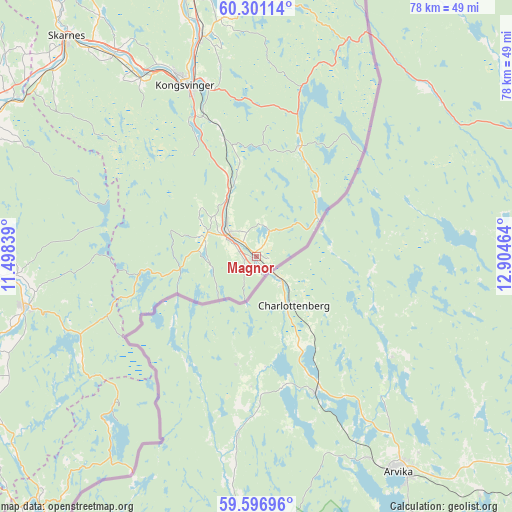
Magnor GPS coordinates[2]
59° 57' 3.312" North, 12° 12' 5.436" East
| Map corner | latitude | longitude |
|---|---|---|
| Upper-left | 60.30114°, | 11.49839° |
| Center: | 59.95092°, | 12.20151° |
| Lower-right: | 59.59696°, | 12.90464° |
| Map W x H: | 78.3×78.3 km | = 48.7×48.7mi |
| max Lat: | 71.04137° ⇑65.8% North |
| Magnor: | 59.95092° |
| min Lat: | ⇓34.2% South 58.0274° |
| min Long | Magnor | max Long |
| 4.71485° | 12.20151° | 31.11066° |
| W 82.4%⇐ | ⇒17.6% E |
Elevation
Elevation of Magnor is 135 m = 443 ft, and this is 30.8 m = 101 ft above average elevation for this country.
| Max E: |
897 m = 2943 ft | 27.7% |
| Magnor | 135 m 443 ft | |
| Avg. | 104.2 m = 342 ft | |
Min E: |
1 m = 3 ft | 72.3% |
See also: Norway elevation on elevation.city.
Geographical zone
Magnor is located in North temperate zone (between Tropic of Cancer and the Arctic Circle). Distance of this North polar circle is 735.3 km =456.9 mi to North.| Distance of | km | miles | from Magnor |
|---|---|---|---|
| North Pole | 3341.1 | 2076.1 | to North |
| Arctic Circle | 735.3 | 456.9 | to North |
| Tropic Cancer | 4060 | 2522.8 | to South |
| Equator | 6665.9 | 4142 | to South |


Nearby cities:
15 places around Magnor: (largest is in red/bold)
• Auli
47.7 km =29.6 mi,  281°
281°
• Aursmoen
42.3 km =26.3 mi,  266°
266°
• Bjørkelangen
36.3 km =22.6 mi,  258°
258°
• Fjellfoten
43.4 km =27 mi,  290°
290°
• Fosser
42.5 km =26.4 mi,  249°
249°
• Haga
47.4 km =29.5 mi, 283°
• Hemnes
48.9 km =30.4 mi,  238°
238°
• Kongsvinger
28.9 km =18 mi,  337°
337°
• Løken
44.5 km =27.7 mi, 247°
• Roverud
34.6 km =21.5 mi,  346°
346°
• Rømskog
31.2 km =19.4 mi,  224°
224°
• Skarnes
44.2 km =27.5 mi,  319°
319°
• Skotterud
5.4 km =3.4 mi,  311°
311°
• Spetalen
30.8 km =19.1 mi,  327°
327°
• Årnes
44.9 km =27.9 mi,  295°
295°
Sources, notices
• [Note1] Compared only with cities in Norway existing in our database
• [Src1] Map data: © OpenStreetMap contributors (CC-BY-SA)
• [Src2] Other city data from geonames.org with taken over terms of usage.
• [Src3] Geographical zone / Annual Mean Temperature by Robert A. Rohde @ Wikipedia
