Skarnes geodata
Skarnes (Hedmark) is a seat of a second-order administrative division; located in Norway in Europe/Oslo (GMT+2) time zone. With population of 2,172 people, there are 181 cities with bigger population in this country. Compared to other cities in Norway, 58.2% of cities are located further ↑North; 79.3% of cities are located further ←West and 73.9% of cities have lower elevation than Skarnes. Note1


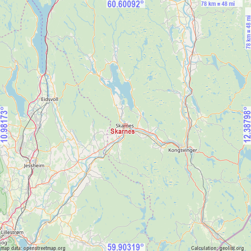
Skarnes GPS coordinates[2]
60° 15' 14.076" North, 11° 41' 5.46" East
| Map corner | latitude | longitude |
|---|---|---|
| Upper-left | 60.60092°, | 10.98173° |
| Center: | 60.25391°, | 11.68485° |
| Lower-right: | 59.90319°, | 12.38798° |
| Map W x H: | 77.6×77.6 km | = 48.2×48.2mi |
| max Lat: | 71.04137° ⇑58.2% North |
| Skarnes: | 60.25391° |
| min Lat: | ⇓41.8% South 58.0274° |
| min Long | Skarnes | max Long |
| 4.71485° | 11.68485° | 31.11066° |
| W 79.3%⇐ | ⇒20.7% E |
Elevation
Elevation of Skarnes is 140 m = 459 ft, and this is 35.8 m = 117 ft above average elevation for this country.
| Max E: |
897 m = 2943 ft | 26.1% |
| Skarnes | 140 m 459 ft | |
| Avg. | 104.2 m = 342 ft | |
Min E: |
1 m = 3 ft | 73.9% |
See also: Norway elevation on elevation.city.
Geographical zone
Skarnes is located in North temperate zone (between Tropic of Cancer and the Arctic Circle). Distance of this North polar circle is 701.6 km =436 mi to North.| Distance of | km | miles | from Skarnes |
|---|---|---|---|
| North Pole | 3307.5 | 2055.2 | to North |
| Arctic Circle | 701.6 | 436 | to North |
| Tropic Cancer | 4093.7 | 2543.7 | to South |
| Equator | 6699.6 | 4162.9 | to South |


Nearby cities:
15 places around Skarnes: (largest is in red/bold)
• Auli
30.3 km =18.8 mi,  216°
216°
• Eidsvoll
24.8 km =15.4 mi,  290°
290°
• Fjellfoten
21.7 km =13.5 mi,  212°
212°
• Haga
28.1 km =17.5 mi, 217°
• Kirkenær
30.6 km =19 mi,  42°
42°
• Kongsvinger
18.7 km =11.6 mi,  112°
112°
• Neskollen
24.1 km =15 mi,  232°
232°
• Nordkisa
24.5 km =15.2 mi,  251°
251°
• Roverud
20.3 km =12.6 mi,  90°
90°
• Råholt
28 km =17.4 mi,  274°
274°
• Sand
17.3 km =10.7 mi,  332°
332°
• Sesvoll
28.6 km =17.8 mi, 269°
• Spetalen
14.2 km =8.8 mi,  123°
123°
• Tomteråsen
23.9 km =14.9 mi, 226°
• Årnes
18.8 km =11.7 mi, 219°
Sources, notices
• [Note1] Compared only with cities in Norway existing in our database
• [Src1] Map data: © OpenStreetMap contributors (CC-BY-SA)
• [Src2] Other city data from geonames.org with taken over terms of usage.
• [Src3] Geographical zone / Annual Mean Temperature by Robert A. Rohde @ Wikipedia
