Myre geodata
Myre (Nordland) is a populated place; located in Norway in Europe/Oslo (GMT+2) time zone. With population of 1,995 people, there are 202 cities with bigger population in this country. Compared to other cities in Norway, 94.3% of cities are located further ↓South; 91.1% of cities are located further ←West and 100% of cities have higher elevation than Myre. Note1


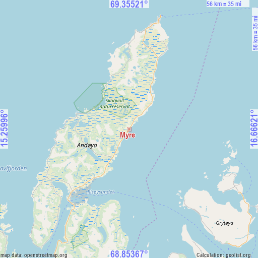
Myre GPS coordinates[2]
69° 6' 21.168" North, 15° 57' 47.088" East
| Map corner | latitude | longitude |
|---|---|---|
| Upper-left | 69.35521°, | 15.25996° |
| Center: | 69.10588°, | 15.96308° |
| Lower-right: | 68.85367°, | 16.66621° |
| Map W x H: | 55.8×55.8 km | = 34.7×34.7mi |
| max Lat: | 71.04137° ⇑5.7% North |
| Myre: | 69.10588° |
| min Lat: | ⇓94.3% South 58.0274° |
| min Long | Myre | max Long |
| 4.71485° | 15.96308° | 31.11066° |
| W 91.1%⇐ | ⇒8.9% E |
Elevation
Elevation of Myre is 1 m = 3 ft, and this is 103.2 m = 339 ft below average elevation for this country.
| Max E: |
897 m = 2943 ft | 100% |
| Avg. | 104.2 m = 342 ft | |
| Myre | 1 m = 3 ft | |
Min E: |
1 m = 3 ft | 0% |
See also: Norway elevation on elevation.city.
Geographical zone
Myre is located in North Frigid zone (between North Pole and Arctic Circle). Distance of this North polar circle is 282.7 km =175.7 mi to South.| Distance of | km | miles | from Myre |
|---|---|---|---|
| North Pole | 2323.2 | 1443.6 | to North |
| Arctic Circle | 282.7 | 175.7 | to South |
| Tropic Cancer | 5077.9 | 3155.3 | to South |
| Equator | 7683.9 | 4774.6 | to South |


Nearby cities:
15 places around Myre: (largest is in red/bold)
• Andenes
24 km =14.9 mi,  14°
14°
• Borkenes
38 km =23.6 mi,  167°
167°
• Brøstadbotn
68.7 km =42.7 mi,  91°
91°
• Evenskjer
63.1 km =39.2 mi,  157°
157°
• Gryllefjord
51.6 km =32.1 mi,  56°
56°
• Hamnvik
60.4 km =37.5 mi,  126°
126°
• Harstad
41.3 km =25.7 mi,  145°
145°
• Hol
64.3 km =40 mi, 164°
• Myre
41.2 km =25.6 mi,  238°
238°
• Sigerfjord
54.5 km =33.9 mi,  199°
199°
• Skaland
64.6 km =40.1 mi,  54°
54°
• Sortland
50.8 km =31.6 mi,  206°
206°
• Stokmarknes
73.5 km =45.7 mi,  215°
215°
• Strand
49.9 km =31 mi, 204°
• Vangsvika
70.5 km =43.8 mi,  84°
84°
Sources, notices
• [Note1] Compared only with cities in Norway existing in our database
• [Src1] Map data: © OpenStreetMap contributors (CC-BY-SA)
• [Src2] Other city data from geonames.org with taken over terms of usage.
• [Src3] Geographical zone / Annual Mean Temperature by Robert A. Rohde @ Wikipedia
