Hopen geodata
Hopen (Møre og Romsdal) is a seat of a second-order administrative division; located in Norway in Europe/Oslo (GMT+2) time zone. In our database, there are 488 cities with bigger population. Compared to other cities in Norway, 77.1% of cities are located further ↓South; 66.8% of cities are located further →East and 92.1% of cities have higher elevation than Hopen. Note1


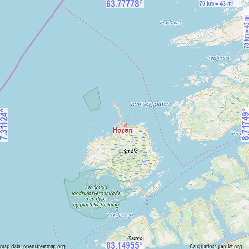
Hopen GPS coordinates[2]
63° 27' 55.404" North, 8° 0' 51.732" East
| Map corner | latitude | longitude |
|---|---|---|
| Upper-left | 63.77778°, | 7.31124° |
| Center: | 63.46539°, | 8.01437° |
| Lower-right: | 63.14955°, | 8.71749° |
| Map W x H: | 69.9×69.9 km | = 43.4×43.4mi |
| max Lat: | 71.04137° ⇑22.9% North |
| Hopen: | 63.46539° |
| min Lat: | ⇓77.1% South 58.0274° |
| min Long | Hopen | max Long |
| 4.71485° | 8.01437° | 31.11066° |
| W 33.2%⇐ | ⇒66.8% E |
Elevation
Elevation of Hopen is 3 m = 10 ft, and this is 101.2 m = 332 ft below average elevation for this country.
| Max E: |
897 m = 2943 ft | 92.1% |
| Avg. | 104.2 m = 342 ft | |
| Hopen | 3 m = 10 ft | |
Min E: |
1 m = 3 ft | 7.9% |
See also: Norway elevation on elevation.city.
Geographical zone
Hopen is located in North temperate zone (between Tropic of Cancer and the Arctic Circle). Distance of this North polar circle is 344.5 km =214.1 mi to North.| Distance of | km | miles | from Hopen |
|---|---|---|---|
| North Pole | 2950.4 | 1833.3 | to North |
| Arctic Circle | 344.5 | 214.1 | to North |
| Tropic Cancer | 4450.8 | 2765.6 | to South |
| Equator | 7056.7 | 4384.8 | to South |


Nearby cities:
15 places around Hopen: (largest is in red/bold)
• Aure
33.8 km =21 mi,  130°
130°
• Batnfjordsøra
65.7 km =40.8 mi,  195°
195°
• Bruhagen
49.7 km =30.9 mi, 202°
• Eide
67.3 km =41.8 mi,  205°
205°
• Eidsvåg
76.6 km =47.6 mi,  178°
178°
• Fillan
49.9 km =31 mi,  71°
71°
• Kristiansund
42 km =26.1 mi, 199°
• Krokstadøra
74.3 km =46.2 mi,  95°
95°
• Kyrksæterøra
57 km =35.4 mi,  109°
109°
• Liabøen
41 km =25.5 mi,  158°
158°
• Rensvik
41.9 km =26 mi,  193°
193°
• Rindal
75.3 km =46.8 mi, 127°
• Sistranda
49.7 km =30.9 mi,  54°
54°
• Surnadal
65.2 km =40.5 mi,  146°
146°
• Tingvoll
62.1 km =38.6 mi,  171°
171°
Sources, notices
• [Note1] Compared only with cities in Norway existing in our database
• [Src1] Map data: © OpenStreetMap contributors (CC-BY-SA)
• [Src2] Other city data from geonames.org with taken over terms of usage.
• [Src3] Geographical zone / Annual Mean Temperature by Robert A. Rohde @ Wikipedia
