Liabøen geodata
Liabøen (Møre og Romsdal) is a seat of a second-order administrative division; located in Norway in Europe/Oslo (GMT+2) time zone. In our database, there are 488 cities with bigger population. Compared to other cities in Norway, 74.1% of cities are located further ↓South; 64.9% of cities are located further →East and 61.9% of cities have lower elevation than Liabøen. Note1


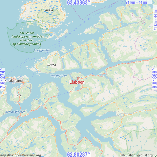
Liabøen GPS coordinates[2]
63° 7' 20.964" North, 8° 18' 57.132" East
| Map corner | latitude | longitude |
|---|---|---|
| Upper-left | 63.43863°, | 7.61274° |
| Center: | 63.12249°, | 8.31587° |
| Lower-right: | 62.80287°, | 9.01899° |
| Map W x H: | 70.7×70.7 km | = 43.9×43.9mi |
| max Lat: | 71.04137° ⇑25.9% North |
| Liabøen: | 63.12249° |
| min Lat: | ⇓74.1% South 58.0274° |
| min Long | Liabøen | max Long |
| 4.71485° | 8.31587° | 31.11066° |
| W 35.1%⇐ | ⇒64.9% E |
Elevation
Elevation of Liabøen is 75 m = 246 ft, and this is 29.2 m = 96 ft below average elevation for this country.
| Max E: |
897 m = 2943 ft | 38.1% |
| Avg. | 104.2 m = 342 ft | |
| Liabøen | 75 m = 246 ft | |
Min E: |
1 m = 3 ft | 61.9% |
See also: Norway elevation on elevation.city.
Geographical zone
Liabøen is located in North temperate zone (between Tropic of Cancer and the Arctic Circle). Distance of this North polar circle is 382.6 km =237.7 mi to North.| Distance of | km | miles | from Liabøen |
|---|---|---|---|
| North Pole | 2988.5 | 1857 | to North |
| Arctic Circle | 382.6 | 237.7 | to North |
| Tropic Cancer | 4412.6 | 2741.9 | to South |
| Equator | 7018.6 | 4361.2 | to South |


Nearby cities:
15 places around Liabøen: (largest is in red/bold)
• Aure
19.4 km =12.1 mi,  33°
33°
• Batnfjordsøra
41.2 km =25.6 mi,  232°
232°
• Bruhagen
35.2 km =21.9 mi,  257°
257°
• Eide
49.4 km =30.7 mi,  242°
242°
• Eidsvåg
40.5 km =25.2 mi,  198°
198°
• Grøa
57.1 km =35.5 mi,  158°
158°
• Hjelset
56.4 km =35 mi, 227°
• Hopen
41 km =25.5 mi,  338°
338°
• Kristiansund
29.6 km =18.4 mi,  267°
267°
• Kyrksæterøra
43 km =26.7 mi,  64°
64°
• Rensvik
25.1 km =15.6 mi, 263°
• Rindal
45.7 km =28.4 mi,  99°
99°
• Sunndalsøra
51.3 km =31.9 mi,  165°
165°
• Surnadal
26.4 km =16.4 mi,  128°
128°
• Tingvoll
23.9 km =14.9 mi,  193°
193°
Sources, notices
• [Note1] Compared only with cities in Norway existing in our database
• [Src1] Map data: © OpenStreetMap contributors (CC-BY-SA)
• [Src2] Other city data from geonames.org with taken over terms of usage.
• [Src3] Geographical zone / Annual Mean Temperature by Robert A. Rohde @ Wikipedia
