Aure geodata
Aure (Møre og Romsdal) is a seat of a second-order administrative division; located in Norway in Europe/Oslo (GMT+2) time zone. With population of 596 people, there are 419 cities with bigger population in this country. Compared to other cities in Norway, 74.8% of cities are located further ↓South; 63.8% of cities are located further →East and 54.9% of cities have lower elevation than Aure. Note1


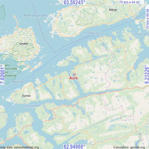
Aure GPS coordinates[2]
63° 16' 4.44" North, 8° 31' 44.868" East
| Map corner | latitude | longitude |
|---|---|---|
| Upper-left | 63.58245°, | 7.82601° |
| Center: | 63.2679°, | 8.52913° |
| Lower-right: | 62.94988°, | 9.23226° |
| Map W x H: | 70.3×70.3 km | = 43.7×43.7mi |
| max Lat: | 71.04137° ⇑25.2% North |
| Aure: | 63.2679° |
| min Lat: | ⇓74.8% South 58.0274° |
| min Long | Aure | max Long |
| 4.71485° | 8.52913° | 31.11066° |
| W 36.2%⇐ | ⇒63.8% E |
Elevation
Elevation of Aure is 60 m = 197 ft, and this is 44.2 m = 145 ft below average elevation for this country.
| Max E: |
897 m = 2943 ft | 45.1% |
| Avg. | 104.2 m = 342 ft | |
| Aure | 60 m = 197 ft | |
Min E: |
1 m = 3 ft | 54.9% |
See also: Norway elevation on elevation.city.
Geographical zone
Aure is located in North temperate zone (between Tropic of Cancer and the Arctic Circle). Distance of this North polar circle is 366.4 km =227.7 mi to North.| Distance of | km | miles | from Aure |
|---|---|---|---|
| North Pole | 2972.3 | 1846.9 | to North |
| Arctic Circle | 366.4 | 227.7 | to North |
| Tropic Cancer | 4428.8 | 2751.9 | to South |
| Equator | 7034.7 | 4371.2 | to South |


Nearby cities:
15 places around Aure: (largest is in red/bold)
• Batnfjordsøra
59.8 km =37.2 mi,  226°
226°
• Bruhagen
50.9 km =31.6 mi,  241°
241°
• Eidsvåg
59.4 km =36.9 mi,  203°
203°
• Fillan
43.5 km =27 mi,  30°
30°
• Hopen
33.8 km =21 mi,  310°
310°
• Kristiansund
43.8 km =27.2 mi,  246°
246°
• Krokstadøra
50.7 km =31.5 mi,  73°
73°
• Kyrksæterøra
28.1 km =17.5 mi,  84°
84°
• Liabøen
19.4 km =12.1 mi,  213°
213°
• Løkken Verk
61 km =37.9 mi,  104°
104°
• Rensvik
40.2 km =25 mi, 242°
• Rindal
41.6 km =25.8 mi,  124°
124°
• Sistranda
53 km =32.9 mi,  16°
16°
• Surnadal
34.1 km =21.2 mi,  163°
163°
• Tingvoll
42.7 km =26.5 mi, 202°
Sources, notices
• [Note1] Compared only with cities in Norway existing in our database
• [Src1] Map data: © OpenStreetMap contributors (CC-BY-SA)
• [Src2] Other city data from geonames.org with taken over terms of usage.
• [Src3] Geographical zone / Annual Mean Temperature by Robert A. Rohde @ Wikipedia
