Svelgen geodata
Svelgen (Sogn og Fjordane) is a seat of a second-order administrative division; located in Norway in Europe/Oslo (GMT+2) time zone. With population of 1,173 people, there are 274 cities with bigger population in this country. Compared to other cities in Norway, 61.9% of cities are located further ↓South; 94.1% of cities are located further →East and 73.9% of cities have lower elevation than Svelgen. Note1


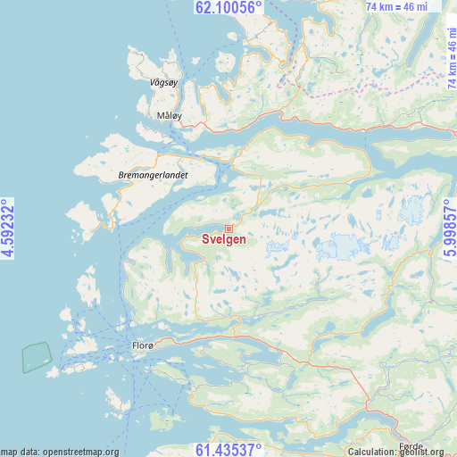
Svelgen GPS coordinates[2]
61° 46' 11.136" North, 5° 17' 43.584" East
| Map corner | latitude | longitude |
|---|---|---|
| Upper-left | 62.10056°, | 4.59232° |
| Center: | 61.76976°, | 5.29544° |
| Lower-right: | 61.43537°, | 5.99857° |
| Map W x H: | 74×74 km | = 46×46mi |
| max Lat: | 71.04137° ⇑38.1% North |
| Svelgen: | 61.76976° |
| min Lat: | ⇓61.9% South 58.0274° |
| min Long | Svelgen | max Long |
| 4.71485° | 5.29544° | 31.11066° |
| W 5.9%⇐ | ⇒94.1% E |
Elevation
Elevation of Svelgen is 140 m = 459 ft, and this is 35.8 m = 117 ft above average elevation for this country.
| Max E: |
897 m = 2943 ft | 26.1% |
| Svelgen | 140 m 459 ft | |
| Avg. | 104.2 m = 342 ft | |
Min E: |
1 m = 3 ft | 73.9% |
See also: Norway elevation on elevation.city.
Geographical zone
Svelgen is located in North temperate zone (between Tropic of Cancer and the Arctic Circle). Distance of this North polar circle is 533 km =331.2 mi to North.| Distance of | km | miles | from Svelgen |
|---|---|---|---|
| North Pole | 3138.9 | 1950.4 | to North |
| Arctic Circle | 533 | 331.2 | to North |
| Tropic Cancer | 4262.2 | 2648.4 | to South |
| Equator | 6868.2 | 4267.7 | to South |


Nearby cities:
15 places around Svelgen: (largest is in red/bold)
• Askvoll
48.6 km =30.2 mi,  194°
194°
• Dale
45.5 km =28.3 mi,  172°
172°
• Fiskå
39.3 km =24.4 mi,  20°
20°
• Florø
23.5 km =14.6 mi,  216°
216°
• Førde
46.1 km =28.6 mi,  139°
139°
• Larsnes
50.4 km =31.3 mi, 16°
• Måløy
20.7 km =12.9 mi,  332°
332°
• Naustdal
36.4 km =22.6 mi, 142°
• Nordfjordeid
39.5 km =24.5 mi,  66°
66°
• Raudeberg
25.3 km =15.7 mi,  340°
340°
• Sandane
48.4 km =30.1 mi,  89°
89°
• Sande
56.1 km =34.9 mi,  151°
151°
• Selje
30.7 km =19.1 mi,  5°
5°
• Volda
58.3 km =36.2 mi,  44°
44°
• Ørsta
64.7 km =40.2 mi, 42°
Sources, notices
• [Note1] Compared only with cities in Norway existing in our database
• [Src1] Map data: © OpenStreetMap contributors (CC-BY-SA)
• [Src2] Other city data from geonames.org with taken over terms of usage.
• [Src3] Geographical zone / Annual Mean Temperature by Robert A. Rohde @ Wikipedia
