Rensvik geodata
Rensvik (Møre og Romsdal) is a populated locality; located in Norway in Europe/Oslo (GMT+2) time zone. With population of 2,121 people, there are 191 cities with bigger population in this country. Compared to other cities in Norway, 73.6% of cities are located further ↓South; 68% of cities are located further →East and 52.7% of cities have higher elevation than Rensvik. Note1


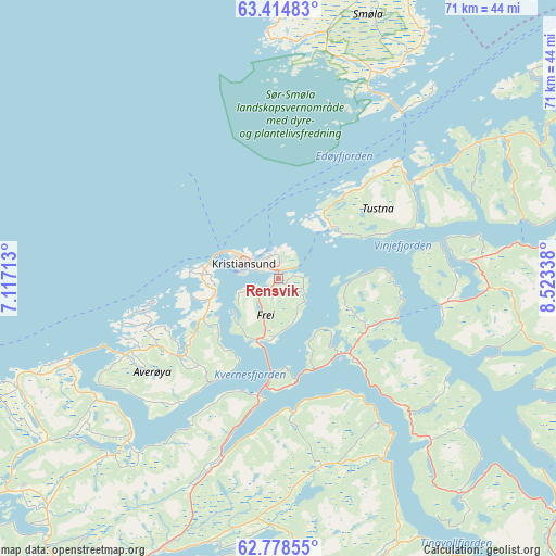
Rensvik GPS coordinates[2]
63° 5' 54.348" North, 7° 49' 12.936" East
| Map corner | latitude | longitude |
|---|---|---|
| Upper-left | 63.41483°, | 7.11713° |
| Center: | 63.09843°, | 7.82026° |
| Lower-right: | 62.77855°, | 8.52338° |
| Map W x H: | 70.7×70.7 km | = 43.9×43.9mi |
| max Lat: | 71.04137° ⇑26.4% North |
| Rensvik: | 63.09843° |
| min Lat: | ⇓73.6% South 58.0274° |
| min Long | Rensvik | max Long |
| 4.71485° | 7.82026° | 31.11066° |
| W 32%⇐ | ⇒68% E |
Elevation
Elevation of Rensvik is 40 m = 131 ft, and this is 64.2 m = 211 ft below average elevation for this country.
| Max E: |
897 m = 2943 ft | 52.7% |
| Avg. | 104.2 m = 342 ft | |
| Rensvik | 40 m = 131 ft | |
Min E: |
1 m = 3 ft | 47.3% |
See also: Norway elevation on elevation.city.
Geographical zone
Rensvik is located in North temperate zone (between Tropic of Cancer and the Arctic Circle). Distance of this North polar circle is 385.3 km =239.4 mi to North.| Distance of | km | miles | from Rensvik |
|---|---|---|---|
| North Pole | 2991.2 | 1858.6 | to North |
| Arctic Circle | 385.3 | 239.4 | to North |
| Tropic Cancer | 4410 | 2740.2 | to South |
| Equator | 7015.9 | 4359.5 | to South |


Nearby cities:
15 places around Rensvik: (largest is in red/bold)
• Aure
40.2 km =25 mi,  62°
62°
• Batnfjordsøra
23.9 km =14.9 mi,  198°
198°
• Bruhagen
10.7 km =6.6 mi,  241°
241°
• Bud
50.4 km =31.3 mi,  245°
245°
• Eide
27.6 km =17.1 mi,  223°
223°
• Eidsvåg
37.9 km =23.5 mi,  160°
160°
• Elnesvågen
43.9 km =27.3 mi,  231°
231°
• Falkhytta
57.4 km =35.7 mi, 235°
• Hjelset
39 km =24.2 mi,  205°
205°
• Hopen
41.9 km =26 mi,  13°
13°
• Kristiansund
4.8 km =3 mi,  286°
286°
• Liabøen
25.1 km =15.6 mi,  83°
83°
• Molde
52.3 km =32.5 mi, 219°
• Surnadal
47.7 km =29.6 mi,  106°
106°
• Tingvoll
28.3 km =17.6 mi,  136°
136°
Sources, notices
• [Note1] Compared only with cities in Norway existing in our database
• [Src1] Map data: © OpenStreetMap contributors (CC-BY-SA)
• [Src2] Other city data from geonames.org with taken over terms of usage.
• [Src3] Geographical zone / Annual Mean Temperature by Robert A. Rohde @ Wikipedia
