Tingvoll geodata
Tingvoll (Møre og Romsdal) is a seat of a second-order administrative division; located in Norway in Europe/Oslo (GMT+2) time zone. With population of 1,005 people, there are 311 cities with bigger population in this country. Compared to other cities in Norway, 72.3% of cities are located further ↓South; 65.8% of cities are located further →East and 52.7% of cities have higher elevation than Tingvoll. Note1


Tingvoll GPS coordinates[2]
62° 54' 47.448" North, 8° 12' 18.936" East
| Map corner | latitude | longitude |
|---|---|---|
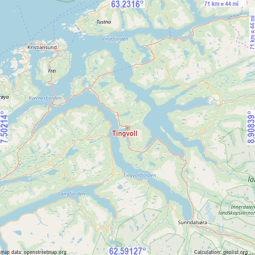
| Upper-left | 63.2316°, | 7.50214° |
| Center: | 62.91318°, | 8.20526° |
| Lower-right: | 62.59127°, | 8.90839° |
| Map W x H: | 71.2×71.2 km | = 44.2×44.2mi |
| max Lat: | 71.04137° ⇑27.7% North |
| Tingvoll: | 62.91318° |
| min Lat: | ⇓72.3% South 58.0274° |
| min Long | Tingvoll | max Long |
| 4.71485° | 8.20526° | 31.11066° |
| W 34.2%⇐ | ⇒65.8% E |
Elevation
Elevation of Tingvoll is 40 m = 131 ft, and this is 64.2 m = 211 ft below average elevation for this country.
| Max E: |
897 m = 2943 ft | 52.7% |
| Avg. | 104.2 m = 342 ft | |
| Tingvoll | 40 m = 131 ft | |
Min E: |
1 m = 3 ft | 47.3% |
See also: Norway elevation on elevation.city.
Geographical zone
Tingvoll is located in North temperate zone (between Tropic of Cancer and the Arctic Circle). Distance of this North polar circle is 405.9 km =252.2 mi to North.| Distance of | km | miles | from Tingvoll |
|---|---|---|---|
| North Pole | 3011.8 | 1871.4 | to North |
| Arctic Circle | 405.9 | 252.2 | to North |
| Tropic Cancer | 4389.4 | 2727.4 | to South |
| Equator | 6995.3 | 4346.7 | to South |


Nearby cities:
15 places around Tingvoll: (largest is in red/bold)
• Aure
42.7 km =26.5 mi,  22°
22°
• Batnfjordsøra
27.1 km =16.8 mi,  265°
265°
• Bruhagen
32.7 km =20.3 mi,  298°
298°
• Eide
38.4 km =23.9 mi, 270°
• Eidsvåg
16.8 km =10.4 mi,  205°
205°
• Elnesvågen
54.5 km =33.9 mi,  263°
263°
• Grøa
39.9 km =24.8 mi,  138°
138°
• Hjelset
39 km =24.2 mi,  247°
247°
• Kristiansund
32.6 km =20.3 mi,  312°
312°
• Liabøen
23.9 km =14.9 mi,  13°
13°
• Rensvik
28.3 km =17.6 mi,  316°
316°
• Rindal
53.2 km =33.1 mi,  72°
72°
• Sunndalsøra
32.1 km =19.9 mi,  145°
145°
• Surnadal
27.1 km =16.8 mi,  75°
75°
• Åndalsnes
46.6 km =29 mi, 214°
Sources, notices
• [Note1] Compared only with cities in Norway existing in our database
• [Src1] Map data: © OpenStreetMap contributors (CC-BY-SA)
• [Src2] Other city data from geonames.org with taken over terms of usage.
• [Src3] Geographical zone / Annual Mean Temperature by Robert A. Rohde @ Wikipedia
