Eidsvåg geodata
Eidsvåg (Møre og Romsdal) is a seat of a second-order administrative division; located in Norway in Europe/Oslo (GMT+2) time zone. With population of 891 people, there are 335 cities with bigger population in this country. Compared to other cities in Norway, 70.7% of cities are located further ↓South; 66.3% of cities are located further →East and 77.8% of cities have higher elevation than Eidsvåg. Note1


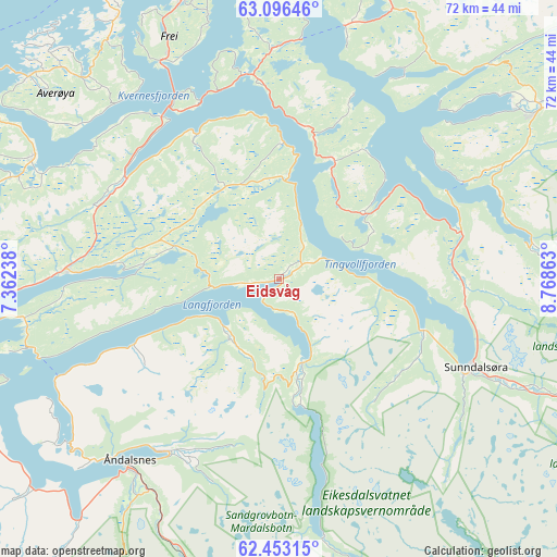
Eidsvåg GPS coordinates[2]
62° 46' 35.616" North, 8° 3' 55.8" East
| Map corner | latitude | longitude |
|---|---|---|
| Upper-left | 63.09646°, | 7.36238° |
| Center: | 62.77656°, | 8.0655° |
| Lower-right: | 62.45315°, | 8.76863° |
| Map W x H: | 71.5×71.5 km | = 44.4×44.4mi |
| max Lat: | 71.04137° ⇑29.3% North |
| Eidsvåg: | 62.77656° |
| min Lat: | ⇓70.7% South 58.0274° |
| min Long | Eidsvåg | max Long |
| 4.71485° | 8.0655° | 31.11066° |
| W 33.7%⇐ | ⇒66.3% E |
Elevation
Elevation of Eidsvåg is 12 m = 39 ft, and this is 92.2 m = 302 ft below average elevation for this country.
| Max E: |
897 m = 2943 ft | 77.8% |
| Avg. | 104.2 m = 342 ft | |
| Eidsvåg | 12 m = 39 ft | |
Min E: |
1 m = 3 ft | 22.2% |
See also: Norway elevation on elevation.city.
Geographical zone
Eidsvåg is located in North temperate zone (between Tropic of Cancer and the Arctic Circle). Distance of this North polar circle is 421.1 km =261.7 mi to North.| Distance of | km | miles | from Eidsvåg |
|---|---|---|---|
| North Pole | 3027 | 1880.9 | to North |
| Arctic Circle | 421.1 | 261.7 | to North |
| Tropic Cancer | 4374.2 | 2718 | to South |
| Equator | 6980.1 | 4337.2 | to South |


Nearby cities:
15 places around Eidsvåg: (largest is in red/bold)
• Batnfjordsøra
23.9 km =14.9 mi,  303°
303°
• Bruhagen
37.7 km =23.4 mi,  324°
324°
• Eide
35.1 km =21.8 mi, 296°
• Elnesvågen
47.9 km =29.8 mi,  280°
280°
• Grøa
36.7 km =22.8 mi,  113°
113°
• Hjelset
29.1 km =18.1 mi,  270°
270°
• Kristiansund
40.9 km =25.4 mi,  335°
335°
• Liabøen
40.5 km =25.2 mi,  18°
18°
• Molde
46.3 km =28.8 mi,  264°
264°
• Rensvik
37.9 km =23.5 mi, 340°
• Sunndalsøra
27.8 km =17.3 mi, 113°
• Surnadal
40 km =24.9 mi,  56°
56°
• Tingvoll
16.8 km =10.4 mi,  25°
25°
• Vestnes
52.7 km =32.7 mi,  251°
251°
• Åndalsnes
30.2 km =18.8 mi,  219°
219°
Sources, notices
• [Note1] Compared only with cities in Norway existing in our database
• [Src1] Map data: © OpenStreetMap contributors (CC-BY-SA)
• [Src2] Other city data from geonames.org with taken over terms of usage.
• [Src3] Geographical zone / Annual Mean Temperature by Robert A. Rohde @ Wikipedia
