Reine geodata
Reine (Nordland) is a seat of a second-order administrative division; located in Norway in Europe/Oslo (GMT+2) time zone. With population of 342 people, there are 475 cities with bigger population in this country. Compared to other cities in Norway, 88.4% of cities are located further ↓South; 84.8% of cities are located further ←West and 100% of cities have higher elevation than Reine. Note1


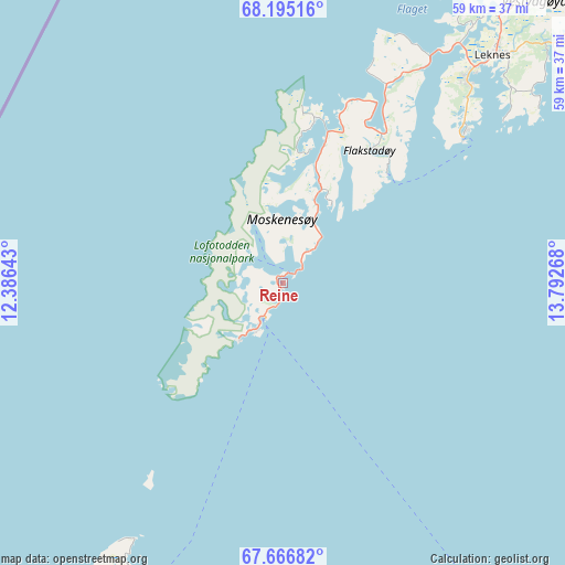
Reine GPS coordinates[2]
67° 55' 56.964" North, 13° 5' 22.38" East
| Map corner | latitude | longitude |
|---|---|---|
| Upper-left | 68.19516°, | 12.38643° |
| Center: | 67.93249°, | 13.08955° |
| Lower-right: | 67.66682°, | 13.79268° |
| Map W x H: | 58.7×58.7 km | = 36.5×36.5mi |
| max Lat: | 71.04137° ⇑11.6% North |
| Reine: | 67.93249° |
| min Lat: | ⇓88.4% South 58.0274° |
| min Long | Reine | max Long |
| 4.71485° | 13.08955° | 31.11066° |
| W 84.8%⇐ | ⇒15.2% E |
Elevation
Elevation of Reine is 1 m = 3 ft, and this is 103.2 m = 339 ft below average elevation for this country.
| Max E: |
897 m = 2943 ft | 100% |
| Avg. | 104.2 m = 342 ft | |
| Reine | 1 m = 3 ft | |
Min E: |
1 m = 3 ft | 0% |
See also: Norway elevation on elevation.city.
Geographical zone
Reine is located in North Frigid zone (between North Pole and Arctic Circle). Distance of this North polar circle is 152.2 km =94.6 mi to South.| Distance of | km | miles | from Reine |
|---|---|---|---|
| North Pole | 2453.7 | 1524.7 | to North |
| Arctic Circle | 152.2 | 94.6 | to South |
| Tropic Cancer | 4947.5 | 3074.2 | to South |
| Equator | 7553.4 | 4693.5 | to South |


Nearby cities:
15 places around Reine: (largest is in red/bold)
• Ballstad
24.7 km =15.3 mi,  50°
50°
• Bodø
91.5 km =56.9 mi,  142°
142°
• Evjen
45.8 km =28.5 mi,  35°
35°
• Gravdal
28.3 km =17.6 mi, 43°
• Kabelvåg
65.3 km =40.6 mi,  61°
61°
• Leinesfjorden
82.6 km =51.3 mi,  102°
102°
• Leknes
32.3 km =20.1 mi, 42°
• Løding
99 km =61.5 mi, 135°
• Løpsmarka
89.7 km =55.7 mi, 140°
• Melbu
94.8 km =58.9 mi, 48°
• Ramberg
18.5 km =11.5 mi,  18°
18°
• Røst
61.7 km =38.3 mi,  221°
221°
• Stamsund
38.5 km =23.9 mi, 55°
• Svolvær
69.9 km =43.4 mi, 61°
• Sørland
33.9 km =21.1 mi,  209°
209°
Sources, notices
• [Note1] Compared only with cities in Norway existing in our database
• [Src1] Map data: © OpenStreetMap contributors (CC-BY-SA)
• [Src2] Other city data from geonames.org with taken over terms of usage.
• [Src3] Geographical zone / Annual Mean Temperature by Robert A. Rohde @ Wikipedia
