Løding geodata
Løding (Nordland) is a populated place; located in Norway in Europe/Oslo (GMT+2) time zone. With population of 2,835 people, there are 135 cities with bigger population in this country. Compared to other cities in Norway, 87.5% of cities are located further ↓South; 89.2% of cities are located further ←West and 60.1% of cities have higher elevation than Løding. Note1


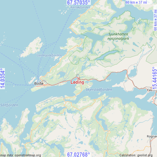
Løding GPS coordinates[2]
67° 18' 1.98" North, 14° 44' 18.672" East
| Map corner | latitude | longitude |
|---|---|---|
| Upper-left | 67.57035°, | 14.0354° |
| Center: | 67.30055°, | 14.73852° |
| Lower-right: | 67.02768°, | 15.44165° |
| Map W x H: | 60.3×60.3 km | = 37.5×37.5mi |
| max Lat: | 71.04137° ⇑12.5% North |
| Løding: | 67.30055° |
| min Lat: | ⇓87.5% South 58.0274° |
| min Long | Løding | max Long |
| 4.71485° | 14.73852° | 31.11066° |
| W 89.2%⇐ | ⇒10.8% E |
Elevation
Elevation of Løding is 27 m = 89 ft, and this is 77.2 m = 253 ft below average elevation for this country.
| Max E: |
897 m = 2943 ft | 60.1% |
| Avg. | 104.2 m = 342 ft | |
| Løding | 27 m = 89 ft | |
Min E: |
1 m = 3 ft | 39.9% |
See also: Norway elevation on elevation.city.
Geographical zone
Løding is located in North Frigid zone (between North Pole and Arctic Circle). Distance of this North polar circle is 81.9 km =50.9 mi to South.| Distance of | km | miles | from Løding |
|---|---|---|---|
| North Pole | 2523.9 | 1568.3 | to North |
| Arctic Circle | 81.9 | 50.9 | to South |
| Tropic Cancer | 4877.2 | 3030.6 | to South |
| Equator | 7483.1 | 4649.8 | to South |


Nearby cities:
15 places around Løding: (largest is in red/bold)
• Bodø
14.5 km =9 mi,  260°
260°
• Fauske
28.4 km =17.6 mi,  99°
99°
• Glomfjord
63.9 km =39.7 mi,  212°
212°
• Inndyr
42.7 km =26.5 mi,  225°
225°
• Leinesfjorden
54.1 km =33.6 mi,  12°
12°
• Løpsmarka
12.5 km =7.8 mi,  276°
276°
• Moldjord
33.5 km =20.8 mi,  192°
192°
• Oppeid
94.7 km =58.8 mi,  22°
22°
• Reine
99 km =61.5 mi,  315°
315°
• Rognan
35.9 km =22.3 mi,  128°
128°
• Stamsund
99.6 km =61.9 mi,  337°
337°
• Straumen
37.5 km =23.3 mi,  81°
81°
• Sørland
95.9 km =59.6 mi,  295°
295°
• Vågaholmen
90.7 km =56.4 mi,  224°
224°
• Ørnes
65.6 km =40.8 mi, 222°
Sources, notices
• [Note1] Compared only with cities in Norway existing in our database
• [Src1] Map data: © OpenStreetMap contributors (CC-BY-SA)
• [Src2] Other city data from geonames.org with taken over terms of usage.
• [Src3] Geographical zone / Annual Mean Temperature by Robert A. Rohde @ Wikipedia
