Løpsmarka geodata
Løpsmarka (Nordland) is a populated locality; located in Norway in Europe/Oslo (GMT+2) time zone. With population of 2,308 people, there are 173 cities with bigger population in this country. Compared to other cities in Norway, 87.7% of cities are located further ↓South; 88.3% of cities are located further ←West and 52.7% of cities have higher elevation than Løpsmarka. Note1


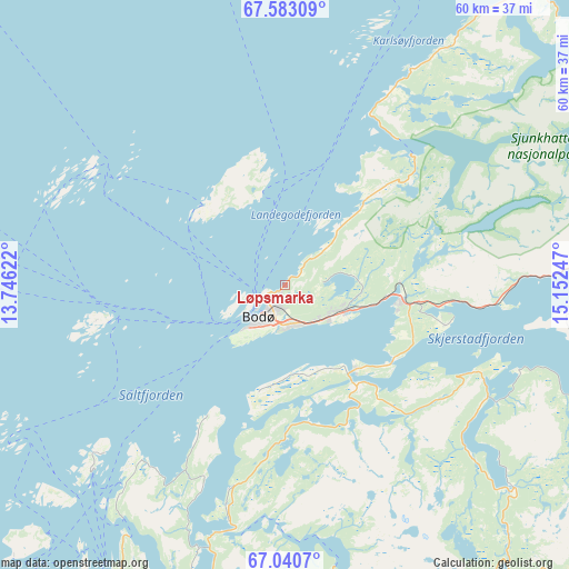
Løpsmarka GPS coordinates[2]
67° 18' 48.348" North, 14° 26' 57.624" East
| Map corner | latitude | longitude |
|---|---|---|
| Upper-left | 67.58309°, | 13.74622° |
| Center: | 67.31343°, | 14.44934° |
| Lower-right: | 67.0407°, | 15.15247° |
| Map W x H: | 60.3×60.3 km | = 37.5×37.5mi |
| max Lat: | 71.04137° ⇑12.3% North |
| Løpsmarka: | 67.31343° |
| min Lat: | ⇓87.7% South 58.0274° |
| min Long | Løpsmarka | max Long |
| 4.71485° | 14.44934° | 31.11066° |
| W 88.3%⇐ | ⇒11.7% E |
Elevation
Elevation of Løpsmarka is 40 m = 131 ft, and this is 64.2 m = 211 ft below average elevation for this country.
| Max E: |
897 m = 2943 ft | 52.7% |
| Avg. | 104.2 m = 342 ft | |
| Løpsmarka | 40 m = 131 ft | |
Min E: |
1 m = 3 ft | 47.3% |
See also: Norway elevation on elevation.city.
Geographical zone
Løpsmarka is located in North Frigid zone (between North Pole and Arctic Circle). Distance of this North polar circle is 83.4 km =51.8 mi to South.| Distance of | km | miles | from Løpsmarka |
|---|---|---|---|
| North Pole | 2522.5 | 1567.4 | to North |
| Arctic Circle | 83.4 | 51.8 | to South |
| Tropic Cancer | 4878.6 | 3031.4 | to South |
| Equator | 7484.6 | 4650.7 | to South |


Nearby cities:
15 places around Løpsmarka: (largest is in red/bold)
• Ballstad
92.8 km =57.7 mi,  335°
335°
• Bodø
4.2 km =2.6 mi,  207°
207°
• Fauske
40.9 km =25.4 mi,  98°
98°
• Glomfjord
59.4 km =36.9 mi,  201°
201°
• Inndyr
36.1 km =22.4 mi, 210°
• Leinesfjorden
56.7 km =35.2 mi,  25°
25°
• Løding
12.5 km =7.8 mi, 96°
• Moldjord
34.6 km =21.5 mi,  171°
171°
• Reine
89.7 km =55.7 mi,  320°
320°
• Rognan
47 km =29.2 mi,  120°
120°
• Stamsund
94.3 km =58.6 mi, 344°
• Straumen
49.7 km =30.9 mi,  85°
85°
• Sørland
84.2 km =52.3 mi,  297°
297°
• Vågaholmen
83.6 km =51.9 mi,  217°
217°
• Ørnes
59 km =36.7 mi, 213°
Sources, notices
• [Note1] Compared only with cities in Norway existing in our database
• [Src1] Map data: © OpenStreetMap contributors (CC-BY-SA)
• [Src2] Other city data from geonames.org with taken over terms of usage.
• [Src3] Geographical zone / Annual Mean Temperature by Robert A. Rohde @ Wikipedia
